Image Lake Glacier Peak North Cascades

Glacier Peak and Image Lake

Image Lake and Glacier Peak

Image Lake Glacier Peak North Cascades
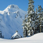
Glacier Peak Image Lake #58240   Purchase

Image Lake Glacier Peak North Cascades
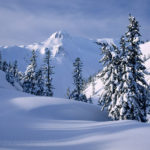
Image Lake Glacier Peak  #58240   Purchase

Recently I made a five-day backpacking trip to one of my all time favorite areas in the North Cascades, Image Lake . Located in the Glacier Peak Wilderness this is one of the classic views of lake mountain glacier in the Northwest. Image Lake is rivaled only by a few other spots such as Picture Lake/Mount Shuksan, and Tipso Lake/Mount Rainier. The big difference here is that you’re not likely to run into crowds, or more than a couple other people for that matter. My last visit to this outstanding location was back in 2000 and I’ve been wanting to get back there ever since.

Image Lake Glacier Peak North Cascades
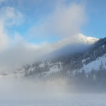
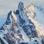
Glacier Peak  Image Lake #58248   Purchase

Due to a series of winter floods, subsequent lack of repair funding, and environmental studies, the Suiattle River access road has been closed for nearly 12 years. I’m not very optimistic that the road will remain open for long. The whole length of the river valley is made up of ancient volcanic debris from past eruptions of Glacier Peak. During the rainy fall and winter months the river routinely eats away at this easily eroded material. Despite extensive repairs there are still several areas where the road is still very vulnerable. It won’t take much, I’m afraid, to put it out of commission again.

Hiking In

Image Lake on Miner’s Ridge is a fairly long backpacking trip that requires at least several days to justify the effort. The total roundtrip mileage is about 32 miles with 4500′ of elevation gain, most of it in the last five miles. Of course there is much more to see than just plopping down at the lake so figure on adding several more miles and another thousand feet or so of elevation to that. On all three of my visits I encountered parties that did it in two days. However, I really don’t see the point of carrying a full load that far and high to take a quick look around and head back the next day. I consider three days a minimum.

Hiker on suspension bridge Suiattle River Trail North CascadesBackpacker on Canyon Creek Bridge #58176   Purchase

The first nine or ten miles travels along the Suiattle River through gorgeous old growth forest with massive trees. One of the highlights comes when crossing Canyon Creek on a very well built suspension bridge. Such a large and sturdy structure is rare in the wilderness. Horses also use this trail so it needs to be able to stand up to heavy weights. At around ten miles the real work begins, non-stop switchbacks from the river valley to the top of the ridge. Fortunately the upward grind is in the shade of forest almost all the way up. On this trip it was fairly cool with heavy overcast and fog. However, the intense humidity had me sweating like a pig while just putting my packing on! When I got to camp I was soaking with sweat.

North Cascades Old Growth ForestOld Growth Forest Glacier Peak Wilderness #58192   Purchase

At The Lake

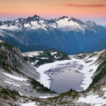
Image Lake itself is nothing to go out of your way to see. It’s a very shallow lake which has a soft sediment bottom, and is usually covered with hatching insects in summer. Image Lake is not the best for swimming, but good to cool your toes off. The real reason that makes the lake so special is its situation on Miner’s Ridge. At about 6000′ high it has a perfectly placed front row seat view of the heavily glacier-cloaked NE face of Glacier Peak.  At 10,541′ Glacier Peak is the most isolated of the five volcanoes in Washington.  It is definitely one of those views you could just sit for hours or days admiring. And since it so far out you’ll most likely have it to yourself! On this trip I had the whole ridge and lake basin to myself for two whole days.

Hiker Glacier Peak Wilderness North cascadesUpper Suiattle River Valley from Miner’s Ridge #58279   Purchase

If you are looking for a truly extraordinary wilderness experience then spend a day or two at the lake before heading east along Miner’s Ridge. This route traverses through high meadows to Suiattle Pass and beyond to Cloudy Pass and glacier fed Lyman Lake. Nearly the entire length of the trail is above tree-line.  Along the way you’ll travel through some of the most astonishing mountain scenery in the North Cascades accessible by trail. Seven to ten days would be perfect to enjoy such a trip and you’ll have memories to last a lifetime.

If you’d like to purchase prints or license any image for commercial use just click on any image or search by keyword.

Glacier Peak and Miners Ridge

North Cascades backcountry camp Miners RidgeCamp on Miner’s Ridge, Dome Peak in distance #58268   Purchase

Glacier Peak Wilderness backcountry camp Miners Ridge North CascadesMiner’s Ridge camp, Glacier Peak in distance #58317   Purchase

Image Lake Glacier Peak Wilderness North CascadesMiner’s Ridge and Image Lake #58322   Purchase


Nooksack Tower North Cascades

North Cascades Washington

North Cascades Washington

As I’ve mentioned in many posts, North Cascades Washington is one of my favorite places to get out and enjoy a rugged wilderness setting, and since I live in Bellingham Washington it is also practically in my backyard. Over the past several weeks I’ve made a few leisurely hikes and backpacks to some of my regular spots. Below are some photos from these trips that help illustrate the wild and rugged nature of this magnificent range. Enjoy!

Nooksack Tower is, in my opinion, one of the coolest and most dramatic looking peaks in the North Cascades. Topping out at a modest 8268′ / 2520m it is an outlier of the Mount Shuksan massif. Nooksack Tower has also been famously  labeled by legendary climber Fred Beckey as one of the most difficult climb in the North Cascades, equaled possibly only by nearby Slesse Mountain (the “Fang”) in British Columbia. In this view from above Hannegan Pass a layer of fresh spring snow adds to the formidable appearance of the tower.

Nooksack Tower North CascadesNooksack Tower #58069  Purchase

Ruth Creek Valley and Nooksack Ridge

Also one of my favorite areas in the North Cascades, Ruth Creek Valley via the Hannegan Pass Trail has some of the greatest views of any low to mid elevation trail in the Northwest. Most other trails at this elevation are deep in dense old growth forest. However, the slopes in this valley are regularly swept clean by avalanches fueled by massive winter snows. This heavily traveled route is also one of the few trails that provide access to the heart of North Cascades National Park. Aside from the great views, Ruth Creek Valley is also notorious for plagues of black flies that swarm around hikers in the heat of summer, be prepared with lots of Deet if you hike here in July or August!

North Cascades WashingtonRuth Creek Valley, North Cascades #58068  Purchase

Backcountry Camping in the Mount Baker Wilderness. This photo is from on the same trip as the two photos above. While it has the looks of a winter setting the amount of snow seen here is typical for late spring in the North Cascades. Most of the higher elevations are not snow free until mid-July, with wildflowers blooming in sub-alpine meadows soon after that. In the distance you can see Nooksack Tower and its relation to the rest of Mount Shuksan.

Backcountry camp North CascadesNorth Cascades Backcountry Camp#58078  Purchase

North Cascades waterfall. This is a typical view just about anywhere in the lower elevations in spring. Lots of snow melt streams and creeks rushing down the slopes into lush green forests. This nameless, as far as I know, waterfall is midway up the trail to Excelsior Peak.

Waterfall North CascadesNorth Cascades Waterfall #58066  Purchase

Fine Art Prints & Commercial Licensing are available by clicking on the image!

North Cascades Washington

Samish Bay, Larrabee State Park Washington

Larrabee State Park Samish Bay Washington

Larrabee State Park Samish Bay Washington

Samish Bay, Larrabee State Park WashingtonSamish Bay #56660  Purchase

Like in many previous years, I’ve been making several visits to Larrabee State Park during the lull between winter and spring. Situated along Samish Bay a few miles south of Bellingham this is one of the best locations for photography in the area. Hikers trail runners and mountain bikers will find numerous trails into the Chuckanut Mountains. For the photographer, the shoreline along the bay is the place to be. Facing out to the famous San Juan Islands the shore is lined with sandstone cliffs and boulders eroded into fascinating formations. There is even a small natural arch dipping into the water if you can find it.

Clayton Beach

Possibly the best location for photos is Clayton Beach at the south end of the park. It is accessed by a trail approximately one-half mile long. Once on the beach, there are great rock formations. M favorite is just to the left of the beach. Back at the main park entrance,  a short trail takes you down to a sandstone formation with more great compositions.

Clayton Beach, Larrabee State Park WashingtonSandstone erosion patterns Clayton Beach #47151  Purchase

If you go you will need to purchase a day-use pass, unreasonably priced at $15. Although a yearly pass for all Washington State Parks, the Discover Pass is $30. The best time for photography in this park is late afternoon to sunset. This is when the golden-colored sandstone glows in the light. Low tide is best since you’ll be able to access more formations. However, since this is a popular park it will be next to impossible to get photos without the sand being tracked out. The good news is that in winter most people leave around sunset. During my last three trips, I had the beach all to myself. It’s a different story though in summer when the park is packed with people.

Clayton Beach, Larrabee State Park WashingtonSandstone pinnacle Larrabee State Park #47154r


Methow Valley Washington in winter

Methow Valley Winter

Methow Valley Winter

Methow Valley Washington in winterClearing fog near Mazama, Washington #56617  Purchase

Last month I made a quick trip to the Methow Valley in north-central Washington for some much-needed fresh air exercise and photos. The weather in western Washington had been fairly warm and rainy. So I headed to the east side of the North Cascades for a quick fix of winter conditions.

The Methow Valley is renowned for its extensive network of perfectly groomed cross-country ski trails and dependable snow cover. The area is also very popular with snowmobilers and backcountry skiers. They access the high country via the closed North Cascades Highway. On this trip, I stayed in the upper part of the valley near the Mazama area where I knew of several good spots for photographing if the light was right. Here are a few of the highlights from this trip.

Methow Valley barn, WashingtonBarn near Mazama, Washington #56601  Purchase

North Cascades Highway winter road closure near Mazama, WashingtonNorth Cascades Highway winter closure, near Mazama, Washington #56605  Purchase

Cross country skiing Methow Valley North CascadesCross-country skier on Methow Valley trails #56646  Purchase

Also, check out Methow Valley Fall Foliage to see another season in the Methow!

Leave No Trace

Please follow the guidelines of Leave No Trace (LNT). The Methow Valley and all other natural areas throughout the world are under incredible pressure from growing amounts of visitors. Please do your part to help preserve these precious areas for future generations!

To learn more about the principles and practicing LNT please take a few minutes to visit the Leave No Trace Center for Outdoor Ethics. Your children and grandchildren will thank you!

Seven Leave No Trace Principles

  • Plan ahead and prepare.                                       
  • Travel and camp on durable surfaces.                 
  • Dispose of waste properly.                                                                         
  • Leave what you find.                                            
  • Minimize campfire impacts (be careful with fire).
  • Respect wildlife.  
  • Be considerate of other visitors.

*Also, be respectful of private property. Many of the locations in this post are adjacent to private property. The Methow Valley Trail system often crosses private property boundaries and exists due to the blessing of local property owners. 

Photos appearing in Methow Valley Fall Foliage are available for Commercial Licensing and Fine Art Prints. Click on any image to purchase, or contact me for more info!

Table Mountain North Cascades Washington

Winter Heather Meadows Recreation Area

Winter Heather Meadows Recreation Area

Table Mountain North Cascades WashingtonTable Mountain Heather Meadows Recreation Area 56528  Purchase

Every winter for nearly twenty years I’ve made at least one visit to Heather Meadows Recreation Area. I come here for a variety of reasons, such as being close to home and one of the few places in the North Cascades with relatively easy access to subalpine and alpine terrain. Also because the scenery is some of the best in the state and the ever changing patterns of snow and light make for unique winter photography opportunities.

On this first trip of the 2015-2016 winter season I came mainly to begin getting in shape and acclimated for upcoming ski-photo tours. Last year was a near bust as far as snowpack is concerned, but so far this year winter storms have pounded the mountains resulting in a pretty impressive base. As of this writing the Mount Baker Ski Area reports 146″ in the upper runs, with more storms lined up waiting to dump more snow. The first break in the weather I’ll head back up for a few days of winter camping and photography.

Backcountry skiers North Cascades WashingtonBackcountry skiers heading up to Artist Point 56540  Purchase

Mount Baker in winter North CascadesMount Baker from Artists Point 56535  Purchase

Nooksack River North Cascades WashingtonNooksack River back down in the valley 56544  Purchase


Heather Meadows Recreation Area in winter

North Cascades Winter

North Cascades Winter

Heather Meadows Recreation Area in winter North CascadesTable Mountain North Cascades #1644b  Purchase

This image of Table Mountain was made near the Mount Baker Ski Area during the record snowfall winter of 1998-99. That epic winter the ski area received a whopping 1140″ of snow. I couldn’t find out what the actual base was but it was enough to have people specially hired to dig out the lifts! It should be noted that this total is from November 1, 1998, to May 12, 1999.

If these statistics aren’t impressive enough you should also be aware that Mount Baker itself, would receive many times the amount of snow than the ski area. No wonder it is perhaps the snowiest glacier-cloaked peak in the lower 48 states.

Today however is a different story, the record year of 1999 is a distant memory. Last winter Northwest ski areas barely managed to keep open for a partial season. Due to unusually warm temperatures and little snow.

Since we are still in the grip of that same El Niño weather pattern the forecasts don’t look much better for this winter. But let us be optimistic, it’s only the second week in November. The mountains are already receiving snow from fall storms. Albeit in higher elevations and still a little warmer than normal.

In the meantime, I’m going to start scheduling some winter photo trips and getting my skis and other gear in shape!

Winter dawn on Mount Baker, North Cascades Washington Mount Baker in winter #47031  Purchase


Bastille Ridge and Coleman Glacier from meadows onHeliotrope Ridge, Mount Baker Wilderness North Cascades Washington #54533

Mount Baker Wilderness Heliotrope Ridge

Mount Baker Wilderness Heliotrope Ridge

Meadows of Heliotrope Ridge North CascadesColeman Glacier, Heliotrope Ridge Wildflowers #54421  Purchase

Summer is nearly over, and now that we’re in that exciting pause before the coming fall season I have some time to catch up on a few posts I’ve been too busy to work on. If you’ve been following my updates you’ll know that most of the height of summer was spent close to home. Specifically the Mount Baker Wilderness of the North Cascades. Fortunately for me, this wilderness is only an hour or two drive from my home. Practically in my backyard. During the month of August, I photographed the following areas accessed via the Mount Baker Highway:

  • Church Mountain
  • Skyline Divide
  • Hannegan Peak
  • Heliotrope Ridge
  • Heather Meadows Recreation Area

Mount Baker Heliotrope Ridge North CascadesMount Baker from Heliotrope Ridge #54423  Purchase

During the last week of August, I was hoping to visit one more spot that might offer good displays of wildflowers. I almost forgot about Heliotrope Ridge. It has been around twelve years since my last visit. And it’s been twenty since I taught a weekend photography workshop there through the North Cascades Institute.

Heliotrope Ridge trail is extremely popular due to the easy and close access to views of the sprawling Coleman Glacier. And also because it is the start to one of the main climbing routes to the summit of Baker. Since I’ve been there before I knew that the best wildflower meadows were up high near the edge of the glaciers and snowfields. I also knew that I would have the place to myself if I went during the week. Sure enough, during my three nights on the ridge, I saw only one other person wandering around. The few climbing parties that set up camp stuck to the glaciers with eyes on the summit.

Heliotrope Ridge Wildflowers North CascadesHeliotrope Ridge Wildflowers #54537  Purchase

The wildflowers of Heliotrope Ridge were markedly different from those on the hikes to Skyline Divide and Hannegan Peak. There I came across fields mainly of valerian, lupine, corn lilies, and heather, but on Heliotrope there was a greater variety of flowers with an emphasis on yellow arnicas. Also since this area is so close to Mount Baker it receives much more snow, therefore the plants had just escaped the confines of winter and began blooming in late August while other subalpine ridges in the area were already well past peak and had gone to seed.

Another thing to do aside from gawking at the views and wildflowers is to wander cross-country, there are no trails at this point. Going west along increasingly barren slopes of mixed volcanic rock and crumbly slate there are numerous rushing snowmelt streams. If you are prepared for steep snowfield/glacier travel then continue higher up to the actual crest of Heliotrope Ridge. Here the ridge consists of a wild display of volcanic cinders jagged blocks of andesite and lava bombs, looking like it just cooled yesterday. Even better though is the view from the ridge of seldom seen Thunder Glacier and basin below Colfax and Lincoln Peaks, this is truly a wild and lonesome area of Mount Baker!

Coleman Glacier Climbers camp on Mount BakerMount Baker climber camp on Heliotrope Ridge #54432  Purchase

Illuminated tent, Mount Baker North CascadesHeliotrope Ridge Camp Mount Baker #54518  Purchase

Forbidden and Boston Peaks from Hidden Lake Peak, North

North Cascades Photography

North Cascades Photography

Forbidden and Boston Peaks from Hidden Lake Peak, North CascadesNorth Cascades sunrise from Hidden Lakes Peak #54196  Purchase

What a great summer season for photography! Despite canceling my last trip in July to British Columbia, due to wildfires, I’ve been very busy adding lots of new images to my files. While waiting for the wildfire season to moderate I’ve returned to several of my favorite locations in the North Cascades. Since this is the height of summer in the mountains I selected some sub-alpine locations. Good displays of wildflowers and rugged vistas were my goal. These locations are mainly in North Cascades National Park, and the Mount Baker Wilderness.

Late July and August is the driest time of the year in the Northwest. It also has the most predictable weather. Sometimes though this means the weather can be a little too good, with empty blue skies. Great for outdoor activities, but not the greatest for photography. Fortunately my timing was spot on and in a few days I was treated to some fantastic lights shows in the mornings and evenings.

Mount Baker Skyline Divide North CascadesMount Baker from Skyline Divide #54244  Purchase

For now I’ll just post some image highlights from the first few locations since I still have tons of editing and processing to do. I also have another summer trip planned to a very exciting new location. That one will put the brakes on any further posts for a few weeks. Stay tuned, and don’t forget that prints and commercial licensing are available for all of these photos!

Pink Heather North Cascades WashingtonPink Heather North Cascades Sunset #542154  Purchase

Mount Shuksan from Skyline DivideMount Shuksan from Skyline Divide #54238  Purchase

North Cascades backcountry campBackcountry Camp on Hidden Lake Peak #54229  Purchase