Rugged headlands near Spillars Cove, Bonavista Peninsula, Newfoundland #79693

Photographing Bonavista Peninsula Newfoundland

Photographing Bonavista Peninsula Newfoundland

Sunset from the rugged coast of Cape Bonavista Newfoundland #79571
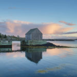
Cape Bonavista Newfoundland #79571  Purchase

This post is the second of several detailing and giving tips for photographing in Newfoundland and Labrador.

Canada’s Atlantic province of Newfoundland and Labrador has some of the most beautiful rugged coastlines in all of North America. And the Central Region of Newfoundland arguably has some of the scenic coastal areas in the province. A visitor can spend weeks exploring the area’s countless coves, peninsulas, inlets, and villages. All of these features are perfect for capturing another famous attraction, icebergs. Riding the Labrador Current down Iceberg Alley many of these icebergs and packs of sea ice end up trapped in the maze of inlets. From May through June icebergs of all sizes and shapes can often be seen moving along the coast or grounded in coves.

For Photographers traveling to Newfoundland for the first time, Bonavista Peninsula, Twillingate Islands, and Fogo Island are great places to photograph icebergs. But there is also much more to photograph. Colorful fishing villages, puffin colonies, historic sites, and spectacular coastal trails, to name a few.

Cape Bonavista Lighthouse on the Bonavista Peninsula Newfoundland and Labrador Canada #79620
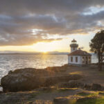
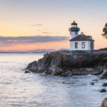
Cape Bonavista Lighthouse Newfoundland #79620  Purchase

Photographing Bonavista Peninsula: Cape Bonavista 

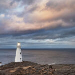
On my recent photo tour of Newfoundland and Labrador, the Bonavista Peninsula was one of my first main stops. At the head of the peninsula, Cape Bonavista has several great spots for photography.  Firstly, there is the squat red and white striped Cape Bonavista Lighthouse. This very photogenic lighthouse sits above the edge of the cape, with the best angles just below its western side. Many photographers also include an old red shack and a wooden fence in disrepair. If there is no wind present good photos can be made of the lighthouse during blue hour light.

Adjacent to it is a monument to John Cabot’s historic first landing on North America in 1497. Although he landed in Newfoundland in 1497, the exact location is still undetermined and disputed.

Double sea cave at Dungeon Provincial Park. Bonavista Peninsula, Newfoundland and Labrador Canada #79637Dungeon Provincial Park Newfoundland #79637  Purchase

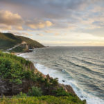
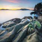
South of the lighthouse on the unpaved Dungeon/Lance Cove Road are numerous excellent places to pull over and just gaze in wonder at the scenery. This road follows a rugged coastline with endless sea stacks and mini coves. One of the highlights here is Dungeon Provincial Park with its angry-looking double sea cave. This is also a UNESCO Discovery Global Geopark site.

Photographing Bonavista Peninsula: The Klondike Trail

A few miles further south is Spillars Cove and the Klondike Trail. The Klondike Trail traverses some of the most spectacular scenery in all of Newfoundland. It traverses the edge of cliffs with incredible views high above the Atlantic. The terrain is a mixture of rocks, heather, mosses, and grass reminiscent of Scotland, or the Arctic.

Cable John Cove, a Discovery UNESCO Global Geopark, Bonavista Peninsula, Newfoundland #79648Cable John Cove Newfoundland #79648 Purchase

At its east end the trail winds around Cable John Cove. For photographers, this cove is where some of the best compositions are, including The Chimney, an eye-popping tall and slender sea stack, which is also a UNESCO Discovery Global Geopark site. A small colony of Atlantic Puffins also nests on a seas tack in this cove.

Photographing Bonavista Peninsula: Elliston and Puffins

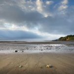
A few miles further south on the main road is the picturesque town of Elliston. Also known as “The Root Cellar Capitol of the World” with 133 documented root cellars. A few of them, like the ones near the puffin viewing site, are worth photographing. The town also has a memorial to the 251 sealers who lost their lives in the Sealing Disaster of 1914. In addition, there is the John C. Crosbie Sealers Interpretation Center. It exists to help bring to life the lives and hardships of sealers in a bygone era. Unfortunately, it was still closed for the season during my visit.

Puffin colony at the Elliston Puffin Site Newfoundland #79588Puffin Colony Elliston Newfoundland #79588

But the real attraction here is the puffin viewing site. The site offers the closest accessible views of a colony of nesting puffins in all of North America. Atlantic Puffins are also the official bird of the province of Newfoundland and Labrador. A short trail leads to a wonderful cliff-edge view of these squat comical seabirds.

Although on my trip in May, I didn’t see any icebergs in the Bonavista area this is a good location to photograph them. May, June, and early are the prime months to see them throughout Newfoundland and Labrador. Check out Iceberg Finder to keep track of current sightings.

Cable John Cove, a Discovery UNESCO Global Geopark, Bonavista Peninsula, Newfoundland #79713Cable John Cove Newfoundland #79713 Purchase

Essential Tips:

  • cape Bonavista is a great area to photograph long-exposure seascapes. Bring a Big and or Little Stopper Neutral Density Filter, or their equivalent.
  • For photographing Puffins, you’ll need at least a 200mm lens. For isolating individual birds a 400mm lens would be the minimum. The photo appearing in this post is heavily cropped from a photo using a 200mm lens.
  • Cape Bonavista is a good location for both morning/sunrise light and evening/sunset light.
  • Iceberg and whale viewing tours are available in the town of Bonavista.
  • Like most of coastal Newfoundland, the Bonavista Peninsula can be very windy. Dress appropriately and be extremely cautious near cliffs.
  • There is ample free primitive camping at John Cabot Municipal Park adjacent to the lighthouse and along the Dungeon/Lance Cove Road.
  • The town of Bonavista has plenty of lodging and all standard amenities.

Rugged headlands near Spillars Cove, Bonavista Peninsula, Newfoundland #79693Cape Bonavista Peninsula #79693  Purchase

Tips for Traveling in Newfoundland

Seasonal Closures: After the weather, seasonal closures were my next introduction to Newfoundland. The official summer/tourist season doesn’t begin here until June 1.

Nearly every provincial park, historic site, visitor’s center, campground, restroom, gift shop, etc., is shut tight until then. Of course, there are exceptions, but they are far and few between. On the other hand, all of this pretty much guarantees that you’ll escape the summer crowds and have most places all to yourself!

Lodging: Since I nearly always car camp on my photo tours, I can’t say much about lodging. However, there are only a few large towns/cities in the province, so you’ll most likely be looking for lodging in very small towns with limited accommodations. Book very early!

Camping: I didn’t find many campgrounds anywhere, aside from provincial and national parks, which were closed. However, free camping is available just about anywhere that isn’t private property. This mainly consists of gravel roads on Crown Land and trailheads.

Rest Areas: There are none! I have to include this since it was such a shock to me. Even driving from St. John’s on the Trans-Canada Highway to the other end of the province there was not one rest area or port-a-potty. Secondary and backroads? Forget about it! Keep that in mind when starting out in the morning after drinking a big mug of coffee, or that breakfast burrito!

Cable John Cove, a Discovery UNESCO Global Geopark, Bonavista Peninsula, Newfoundland #79695Cable John Cove Bonavista Peninsula #79695  Purchase

To see more images check out these galleries:
Newfoundland and Labrador 1
Newfoundland and Labrador 2

Check out our new Newfoundland Sea, Sky Land, Ice Fine Art Folio

Also, Check out the first post in this series:
Photographing in Newfoundland and Labrador/Cape Spear

Coming up next: Photographing, Twillingate, and Fogo Island 

All photos appearing in Photographing in Newfoundland and Labrador/ Cape Spear are available for Commercial Licensing and Fine Art Prints. Click on any image to purchase, or contact me for more info!

Photographing in Newfoundland

One of two lighthouses at Cape Spear Lighthouse National Historic Site in St. John's, Newfoundland and Labrador, Canada #79487

Photographing in Newfoundland and Labrador/ Cape Spear

Photographing in Newfoundland and Labrador/Cape Spear

One of two lighthouses at Cape Spear Lighthouse National Historic Site in St. John's, Newfoundland and Labrador, Canada #79487 Cape Spear Newfoundland #79487  Purchase

This post is the first of several detailing and giving tips for photographing in Newfoundland and Labrador.

Canada’s Atlantic Province of Newfoundland and Labrador is a destination that will thrill any photographer. It has many characteristics of more popular North Atlantic destinations, such as Scotland and Iceland, including miles of beautiful rugged coastline, colonies of seabirds, and quaint towns with a rich cultural history. It also has very friendly locals with delightfully unique accents. But unfortunately Newfoundland doesn’t have active volcanoes or haggis.

Newfoundland and Labrador also have one other big attraction that the aforementioned destinations don’t: Icebergs. Throughout the year, the Labrador Current reliably transports icebergs from Greenland and the Arctic down Iceberg Alley, to the coast of Newfoundland. The ever-changing shapes and sizes of the bergs provide an additional element of drama to photo compositions. And considering the exorbitant cost of travel to the high Arctic or Antarctica, photographing icebergs in Newfoundland is a hard-to-pass-up bargain!

Iceberg and Pack Ice near Twillingate, Newfoundland and Labrador Canada #79746Iceberg and Pack Ice Newfoundland  #79746 Purchase

This spring, I was able to plan my first extended trip to Newfoundland and Labrador. I began by compiling a list of subject matter I wanted to photograph. Topping the list were icebergs, rugged coastlines, seabird colonies, lighthouses, and finally, fishing villages. After countless hours of poring over maps, tourism websites, and extensive Google searches, I came up with a rough itinerary. As always, I built in lots of flexibility to work around bad weather and other unforeseen circumstances.

I had 24 days allotted for photographing in Newfoundland, and the plan was to fly to St. John’s and then drive to my main destinations of Bonavista Peninsula, Twillingate, and Fogo Island. If time allows, I would take a ferry to Labrador, then return to photograph L’anse Aux Meadows and surrounding areas. Lastly came several locations on the Avalon Peninsula south of St. John’s. In the end, I photographed nearly every location and subject on my list.

One of two lighthouses at Cape Spear Lighthouse National Historic Site in St. John's, Newfoundland and Labrador, Canada #79534Cape Spear Lighthouse Newfoundland #79534  Purchase

Cape Spear Lighthouse National Historic Site

Since I was flying into St. John’s I wanted my first destination to be nearby so I could get my bearings after a long travel day.  Cape Spear Lighthouse National Historic Site was the logical choice, as it was just outside of the city and very photogenic. It turned out to be a great choice and also a harsh introduction to Newfoundland weather.

My home in Bellingham, Washington, and St. John’s are nearly the same latitude. But while at home, there was beautiful spring weather, Newfoundland was still gripped in late winter conditions. Temperatures were in the low 40s, vegetation was still winter brown, and the wind was nonstop and piercing cold. I was glad all my winter clothing came with me!

Cape Spear is a headland on the eastern edge of the Avalon Peninsula. It is also the easternmost point of land in Canada and the North American continent, excluding Greenland. It is so far east that you can almost imagine seeing Ireland on the horizon. There is a lot to see at Cape Spear Lighthouse National Historic Site. It sports two picturesque but distinctly different historic lighthouses. The site also has a WWII gun battery and radar station. You can also start for a hike on the East Coast Trail or just sit and watch for whales.

Cape Spear also has a visitor center with guided tours of the lighthouses. However, these amenities, and every other throughout Newfoundland and Labrador, as I was to find out, were still closed for the season.

Stairway below Cape Spear Lighthouse. Cape Spear Lighthouse National Historic Site in St. John's, Newfoundland and Labrador, Canada #79521Cape Spear Lighthouse Newfoundland #79521  Purchase

Photographing at Cape Spear

Cape Spear Lighthouse National Historic Site and the immediate surrounding area can be explored in a few hours. The lighthouses, of course, are the main attractions for photographers. But hiking a mile or so north or south from the parking lot on the East Coast Trail is also rewarding with additional photo opportunities.

Essential Tip:  This is a location that is good for both morning/sunrise and evening/sunset light. If the weather is poor and you have time, like I did, it’s worth trying to stick around an extra day or two for good light.

One of two lighthouses at Cape Spear Lighthouse National Historic Site in St. John's, Newfoundland and Labrador, Canada #79526Cape Spear Lighthouse Newfoundland #79526  Purchase

Essential Tip: There are many elements here that you can utilize for excellent compositions. Most notably, the stairs on the trail to and below the lighthouses and the white picket fence along the original upper lighthouse. The bedrock along the bluff, which glows reddish brown in evening and morning light, is also worth including.

Essential Tip: You’re nearly guaranteed to have windy conditions here, so make sure to bring a sturdy tripod. And don’t forget to bring a warm, windproof jacket or coat. Leave your hat in the car because it’ll easily be blown away. In fact, use utmost caution along the top of the bluffs as the winds can easily be strong enough to blow you and or your gear over the cliffs! There are a few compositions here that can tempt photographers to inch dangerously close to the edge.

Cape Bay near St. John's, Newfoundland and Labrador, Canada #79492Cape Bay Newfoundland #79492 Purchase

Back down at Cape Bay, it’s worth hiking a short way to Cantwells Cove. The slanted rock formations here and the finger-like inlets are great in the right light, especially for sunrise.

Aside from a steady tripod, lenses from ultra-wide to telephoto will come in handy. Seabirds aren’t plentiful at Cape Spear, but if whales are present, a long telephoto could be useful.

White fence at Cape Spear Lighthouse National Historic Site in St. John's, Newfoundland and Labrador, Canada #79461Cape Spear Lighthouse Newfoundland #79461  Purchase

Practicalities for Photographing in Newfoundland

Since this was my first photo tour of Newfoundland and Labrador, I don’t profess to be an expert on the location. However, as you might expect, I did come away with some very useful information to pass on.

Weather:  Newfoundland and Labrador weather has a temperate marine climate. Summer temperatures are generally cooler and rarely hot and humid. During my trip in May, the wind, sometimes very strong and sustained, was a nearly constant companion. Temperatures reached into the low 60s on only a few rare days and were mostly in the 40s to low 50s. One morning in Twillingate I even woke up to an inch of snow!

Warm wind and rainproof clothing are essential. Boggy, marshy terrain is present nearly everywhere in the province, so good waterproof footwear is also a must.

Sea ice in Sleepy Cove Newfoundland and Labrador Canada #79988Pack Ice Twillingate Island Newfoundland #79988  Purchase

Icebergs: Research advised me that May through June was the best time for viewing icebergs. That appears to be true, but I could add a bit to that. In addition to icebergs, there was quite a lot of pack ice present in some locations, which added another dramatic element to my images. Pack ice is most likely an early-season phenomenon and not present during summer. It also moves around quite a bit, especially when the wind changes direction. One day a cove can be choked with ice, and the next day it can be completely free of it.

Coastal areas of central Newfoundland, such as Twillingate, appear to receive the lion’s share of icebergs. There are many iceberg boat tour companies in the area, and I highly advise booking a tour on one. You’ll safely get much closer to bergs this way, and it’s fascinating to see one up close.

Iceberg Finder is an excellent source to keep track of where iceberg are located before, during, and after a Newfoundland visit.

Cape Race Road Newfoundland #80608Cape Race Road Newfoundland #80608 Purchase

Traveling while Photographing in Newfoundland

Seasonal Closures: After the weather, seasonal closures were my next introduction to Newfoundland. The official summer/tourist season doesn’t begin here until June 1.

Nearly every provincial park, historic site, visitor’s center, campground, restroom, gift shop, etc., is shut tight until then. Of course, there are exceptions, but they are far and few between. On the other hand, all of this pretty much guarantees that you’ll escape the summer crowds and have most places all to yourself!

Lodging: Since I nearly always car camp on my photo tours, I can’t say much about lodging. However, there are only a few large towns/cities in the province, so you’ll most likely be looking for lodging in very small towns with limited accommodations. Book very early!

Camping: I didn’t find many campgrounds anywhere, aside from provincial and national parks, which were closed. However, free camping is available just about anywhere that isn’t private property. This mainly consists of gravel roads on Crown Land and trailheads.

Rest Areas: There are none! I have to include this since it was such a shock to me. Even driving from St. John’s on the Trans-Canada Highway to the other end of the province there was not one rest area or port-a-potty. Secondary and backroads? Forget about it! Keep that in mind when starting out in the morning after drinking a big mug of coffee, or that breakfast burrito!

To see more images check out these galleries:
Newfoundland and Labrador 1
Newfoundland and Labrador 2

Check out our new Newfoundland Sea, Sky Land, Ice Fine Art Folio

Also, check out the next post in this series:
Photographing Bonavista Peninsula Newfoundland

Sunset at the rocky and rugged coast of Cape Bonavista Newfoundland #79565Cape Bonavista Sunset Newfoundland #79565 Purchase

All photos appearing in Photographing in Newfoundland and Labrador/ Cape Spear are available for Commercial Licensing and Fine Art Prints. Click on any image to purchase, or contact me for more info!

Photographing in Newfoundland

Sunset over Lime Kiln Lighthouse and Haro Strait. Lime Kiln Point State Park San Juan Island Washington #79304

Photography News Spring 2023

Sunset over Lime Kiln Lighthouse and Haro Strait. Lime Kiln Point State Park San Juan Island Washington #79304Lime Kiln Point Lighthouse SanJuan Island #79304  Purchase

This spring I have some very exciting photography news to share with everyone. Although it has been a while since my last post, a lot has been going on behind the scenes. Among the photography news are new image additions, new locations scheduled, and a field class with North Cascades Institute.

New Locations Scheduled for Spring 2023

Vancouver Island British Columbia. This month we will be photographing in Ucluelet on the coast of Vancouver Island. Although I live within viewing distance of Vancouver Island this will be our first photography trip there. Over the years I’ve mainly photographed coastal areas of Washington and Oregon. So the beaches, sea stacks, and coves of the Ucluelet area will be a real treat!

Newfoundland. In May I will be spending most of the month photographing along Newfoundland’s Iceberg Alley. My last trip to Canada’s Atlantic Provinces was in Nova Scotia in 2016. But even before that trip, I’ve been itching to visit Newfoundland

May and June are the optimal months for viewing icebergs along the coast. So, hopefully, I’ll be in the right place at the right time to see and photograph some large bergs. While icebergs are high on my shoot list there is plenty more subject matter available.  Below are some of the locations I have so far penciled in.

  • Twillingate
  • Fogo Island
  • Bonavista Peninsula
  • L’Anse aux Meadows National Historic Site
  • Cape Spear
  • Gros Morne National Park

New Images

 There is also some exciting news in the new images department. Check out the New Additions gallery to see selections from these recently added locations.

  • Orcas Island
  • San Juan Island
  • Deception Pass State Park
  • Bellingham Bay

Sunset over Cattle Point and Strait of Juan de Fuca, San Juan Island Washington #79196Cattle Point sunset San Juan Island #79196  Purchase

Sunrise clouds over Deception Pass, Deception Pass State Park, Washington #78952Deception Pass #78952  Purchase

In addition, I’ve also been busy working on some entirely new and fun subject matter. During the dreary winter days this year, I began working on some studio setups of culinary still life.  Although I’m primarily a landscape and nature photographer, this subject matter harkens back to my days working in commercial photography studios in Chicago.

Spices and dried orange slices on a blue stoneware plate, with cinnamon sticks, and star anise resting on an antique spoon #79064Spices and dried orange slices #79064  Purchase

You can see some of the first additions in the Culinary Still Life gallery.

Outdoor Field Class

On Saturday, June 3 I will lead a one-day field class through the North Cascades Institute. Entitled Mindful Photography at Baker Lake this class will be a continuation of the same class I lead in 2021. The course will emphasize using photography to see and interact with the natural environment.

North Cascades old-growth forest Mt. Baker-Snoqualmie National Forest Washington #77662orOld-Growth Forest North Cascades #700662  Purchase

Baker Lake in the spring is an ideal location for this course. Walking along an easy trail we’ll pass through forests of giant old-growth trees, rushing streams and waterfalls, and spring wildflowers.

This class has a limit of 15 participants, so sign up early!

New Fine Art Print Paper

Lastly on the photo news list is an update to my Fine Art Print offerings. For those opting for a fine art print that will be matted and framed, I’ve replaced traditional chromogenic prints made on Fuji Crystal Archive paper with a Giclee-style paper.

Hahnemühle Photo Rag Baryta Fine Art Giclee Prints

I’ve always been partial to the look and feel of old-style darkroom prints made on fiber-based paper. So after conducting some testing, I’ve chosen to offer prints made using Hahnemühle Photo Rag Baryta. It is widely available in all the sizes I offer. And it is one of the highest quality giclee papers available, with a very heavy weight and soft luster finish, characteristics that resemble traditional silver gelatin darkroom prints.

Photography News Spring 2023

Oregon Dunes National Recreation Area

Oregon Coast Photography Trip

Oregon Dunes National Recreation AreaOregon Dunes National Recreation Area #44164  Purchase

This week we will be leaving for a ten day photo shoot on the Oregon Coast. Our usual plan is to photograph coastal locations in April or early May but this year we had to postpone it for obvious reasons. However after several months of enduring Stay At Home orders filled with endless home improvement projects we can’t wait to hit he road again and get back to work!

At this writing only about half of Oregon State parks along the coast are open for camping. So we’re a bit limited on our options. Fortunately a few choice locations are open, enabling us to photograph some areas we haven’t visited in a number of years.  We will be starting at Shore Acres State Park with its whimsical sandstone cliff formations, and Bandon Beach‘s iconic sea-stacks. Then we’ll move north to the Oregon Dunes, and finally on to the Cannon Beach area.

Shore Acres State Park OregonShore Acres State Park Oregon #48703  Purchase

If you’re also visiting any of these areas at the same time let me know, I’d love to meet up and chat!

While this long awaited trip to the Oregon Coast is exciting in its own right, it’s only just the beginning. Several days after returning home I’ll be leaving on an extended photo tour of the Rocky Mountains. In some ways it will be a continuation of last year’s epic trip to the Idaho Sawtooths and Wyomings Wind River Range.

Bandon Beach OregonBandon Beach Oregon #48491  Purchase

This trip will be backpacking oriented and destinations are still in the planning stage.  However they most likely will include the White Cloud Wilderness of Idaho, Wind River Range, and Bob Marshall Wilderness of Montana. If time and conditions allow a few backcountry spots in Glacier National Park may be included. After returning from the Oregon Coast I’ll post a formal announcement for this trip.

Cannon Beach from Ecola State Park OregonCannon Beach from Ecola State Park Oregon #5627b  Purchase

All photos appearing in Oregon Coast Photography Trip are available for Commercial Licensing and Fine Art Prints

Want to learn more? Take your Creative Photography to the next level with  Private Instruction and Guided Photo Tours.


Lime Kiln Lighthouse San Juan Island Washington

Lime Kiln Point State Park

Lime Kiln Point State Park

Lime Kiln Lighthouse San Juan Island Washington #64955Lighthouse at Lime Kiln Point#64955  Purchase

Lime Kiln Point State Park is located on the west side of San Juan Island in the San Juan Islands of Washington State. Facing Haro Strait and Vancouver Island, the park is one of the best spots in the world to view wild killer whales from the land.

The park is not very large, and it isn’t a quick drive destination. In fact, it can take a bit of prior planning to make a trip worthwhile. This is mainly due to the need to take a ferry to Friday Harbor on San Juan Island. Since the park and ferry terminal are on opposite sides of the island you’ll also need to take your vehicle along for the ride. But don’t think you can just drive up to the terminal and be loaded on the ferry! The San Juan Islands are a very popular destination, especially on summer weekends. So to avoid ruining your outing you’ll need to reserve a spot in advance. Scroll down to the bottom of this post for some travel tips!

Killer Whales San Juan IslandsKiller Whales off San Juan Island

Marine Life

If you’re visiting Lime Kiln Point for viewing marine life you won’t be disappointed. The surrounding waters are home to the Southern Resident Killer Whales. They are a group of about 75 killer whales, or orcas, that live for most of the year in this part of the Salish Sea. Aside from orcas, sea lions, seals, porpoises, and minke whales frequent these waters.  On our visit, there were numerous sea lions playing close to the shore. But don’t expect close-up personal views of orcas, they swim farther offshore. Bring your binoculars or spotting scope for good views, predictably we forgot ours. The photo above is from several years ago on a whale-watching tour.

It should be noted here that the Southern Resident Killer Whales are considered an endangered species. Their population has dropped from 85 to 75 individuals in recent years. This is mainly due to a drastic reduction of their prime food source, coho salmon. Their situation is compounded by numerous other factors, including increased stress due to noise levels from pleasure boats and freighter traffic. To learn more please check out the Center for Whale Research.

Roche Harbor San Juan Island Roche Harbor  #64910  Purchase

Touring San Juan Island

The park was our main destination for photos, but since we arrived early we had all day to explore the entire island for more subject matter. Another lighthouse at Cattle Point at the southern tip of the island was on my shoot list. However, the lighting conditions there we not very good so I’ll need to return in the future to photograph it.

Roche Harbor is a historic seaside resort town on the northwest tip of San Juan Island. Here can be found Hotel De Haro, the state’s oldest continually operating hotel, in business since 1886. Judging by the looks of it Roche Harbor is the go-to destination for the yachting crowd. There is plenty of lodging and dining here, along with a general store well stocked with a variety of wines.

While on San Juan Island you can also check out English Camp and American Camp. These are part of San Juan Island National Historical Park. Not many people know that The United States and Great Britain nearly went to war in 1859 over possession of the island. The only casualty of this near conflict was a pig. Thus the incident went down in history to be known as The Pig War.

Container Ship Strait of Juan De Fuca Salish Sea Container Ship #64926  Purchase

Photographing at Lime Kiln

After our short tour of the Island, we drove back to Lime the park in time for evening light and sunset. The lighthouse is the most obvious subject matter here. However, there are also great views south of the Olympic Mountains. I found them to work well as a backdrop for telephoto shots of freighters, and also on their own. Of course, there is also marine life. You’ll need a good telephoto lens for photographing killer whales.

Lime Kiln Lighthouse San Juan Island Washington Lime Kiln Point State ParkLime Kiln Point Lighthouse #64939  Purchase

The lighthouse photographs are best in the evening and sunset. There are plenty of excellent spots on the rocky shore to set up different compositions. A variety of focal lengths will work here, from wide to short telephotos. The classic south-side view of the lighthouse will be illuminated much better in winter when the sun is further south. However, at that time you’ll need to create a wide panoramic to include the sunset and structure in the same frame. In summer the north side will be in sunlight. Then you can photograph the lighthouse looking south with the Olympic Mountains as a backdrop. Unfortunately from this angle, there are few spots to set up your tripod, so getting a good composition may be difficult.

Lime Kiln Lighthouse San Juan Island Washington Lime Kiln Point State ParkLime Kiln Lighthouse #64906  Purchase

How to get to Lime Kiln Point

As mentioned above, you’ll need to review the ferry schedule carefully and reserve a vehicle spot in advance. You can still drive on without a reservation, but I definitely wouldn’t recommend it. On a Friday or Saturday in summer it appears like everyone in the state is going to the islands. You won’t need a reservation if you are just walking on or taking a bicycle. But remember the park is not within walking distance from the ferry terminal at Friday Harbor.

Ferry approaching Orcas Island dockSan Juan Islands Ferry  #64889  Purchase

There are two ferry routes to Friday Harbor, one is a direct nonstop passage from Anacortes. The other makes three stops, at Lopez Island, Orcas Island, and Shaw Island. If you have the time I recommend the latter. It’s a much longer passage but more scenic as the ferry sails past numerous picturesque islands. If possible, try to time your return ferry passage for the evening before sunset. There are excellent photo opportunities then, with the islands and Mount Baker bathed in warm light!

Thanks for reading this post, I hope you enjoyed it. Please consider sharing it with friends family and colleagues!

All photos on this post are available as fine art prints and for commercial licensing.

Wildcat Cove Samish Bay Sunset Larrabee State Park

Bellingham Bay Samish Bay

Bellingham Bay Samish Bay

Taylor Dock Boardwalk Boulevard Park Bellingham WashingtonTaylor Dock Boardwalk, Bellingham WA  #64663  #Purchase

2018 is turning out to be a year of new beginnings. Along with the launching of my new website comes this first blog post of the year, featuring several new images. These new photos are even more special in that are the first made using an entirely new camera system.

Last week during a brief window of decent weather I took a short break from working on the new website. This break enabled me to finally get out in the field to test out my new Nikon D850 camera system and a couple new filters. I find reading and writing reviews of photo gear a huge bore. So, if you’re interested in my opinions of the D850 you can contact me. I’ll be happy to share my first impressions.

The first photo above is from Boulevard Park, along Bellingham Bay. Aside from the new camera and lens, this was my first photo using a Lee Big Stopper filter. For those not familiar, the Big Stopper is a neutral density filter that dramatically increases the length of exposure. This extended shutter speed results in any movement becoming blurred. In the case above, the sky and water took on a silky texture. Photographing after sunset during the “Blue Hour” adds to the mood with cooler saturated tones.

Larrabee State Park

Wildcat Cove Sunset, Samish Bay Larrabee State Park, WashingtonWildcat Cove Sunset, Larrabee State Park  #64680  Purchase

The next day I decided to head down to one of my favorite local winter destinations, Larrabee State Park. Usually I stop by Clayton Beach on the south end of the park. However, since I’ve made numerous photos from that great location I decided to check out Wildcat Cove beach. I haven’t been there for many years and I forgot how scenic it can be.

Wildcat Cove Samish Bay Sunset Larrabee State ParkWildcat Cove Sunset, Larrabee State Park  #64695  Purchase

The tide was going out, exposing some interesting and extremely slippery rocks. The winter light was also warm and pleasant with some nice wispy high clouds. Since it was mid-week there weren’t many people. So it was nice to leisurely set up my gear and make a few photos as the sun went down.

I wanted to get in more practice with the Lee Filters so I made couple more tries. Exposures of even a few minutes long seem to take forever when  it’s getting dark and cold!

Wildcat Cove Samish Bay Sunset Larrabee State ParkWildcat Cove Sunset, Larrabee State Park  #64696 

Want to Learn More?

Would you like to learn more about photography? I offer full day, half day, and multi-day photo tours and instruction. Check out my Private Instruction/Tours page for more info, or contact me directly. I would love to help you take your photography to the next level and shoot like a pro!


Blue Rocks Nova Scotia

Bluenose Coast Nova Scotia

Blue Rocks Nova ScotiaBlue Rocks Nova Scotia  #58819   Purchase

Bluenose Coast Nova Scotia

In my last post, I left off with our departure from Cape Breton Island Nova Scotia. In this post, I’ll be talking about our visit to the Bluenose Coast of Nova Scotia. This area of Nova Scotia has been high on my photography wish list for many years. Bluenose Coast contains some of the most famous tourist attractions in the Province. Situated southwest of Halifax the area includes Peggy’s Cove, and the lovely coastal villages of Chester, Mahone Bay, Lunenburg, and Blue Rocks. How the term Bluenose originated is up for debate, some say it is a derisive term dating to political divisions of the late eighteenth century. However, others will say it refers to a bluish variety of potato or the nose color of locals in winter.

Rowboat, Blue Rocks Nova ScotiaBlue Rocks, Nova Scotia  #58804  Purchase

Our drive from Cape Breton Island down to the Bluenose Coast was again a long tiring journey. Not only was the weather rainy discouraging, but the route we took was also longer than anticipated. Instead of taking a direct course via the main highway, we decided on a more scenic drive along the coast. While I won’t say this was a mistake we did find the road to be exceedingly long with very few coastal views. Most of the way traveled through heavily forested lands dotted with tiny villages. Occasionally the roads break out on the coast with views of numerous islands. According to our travel brochures, this area northeast of Halifax is a haven for wilderness-loving sea kayakers. I’d love to be able to return and explore this vast area with a boat.

The Fo’c’sle Pub Nova ScotiaThe Fo’c’sle Pub Chester, Nova Scotia #58700 

At Chester

Between the rain and the torturous road, we decided to finish the drive to Bluenose Coast the next day. We weren’t too thrilled at the prospect of finding our way through the Halifax area at night. After anxiously getting through Halifax in the morning we decided to base our stay at Graves Island Provincial Park. Well situated near all the sites I was hoping to photograph, Graves Island also had some of the best campsites on our trip. After setting up camp we went on to check out the nearby town of Chester. Founded in 1759, Chester is a quaint village on Mahone Bay noted for stately old homes and a thriving artist community. Along with a boat-filled harbor, Chester is also home to The Fo’c’sle, Nova Scotia’s oldest pub. I couldn’t resist photographing the whimsical dragon hanging above the entrance.

After a few weeks of photographing mostly nature-oriented locations, we were finally in Coleen’s environment. Picturesque coastal towns with lots of shops to browse through were something she had been looking forward to. Although I’m mostly a wilderness nature lover I also was enjoying the change. The next day was perhaps the most memorable of the entire trip. It was a big day with lots of sites to see and photograph on the Bluenose Coast. We began it with breakfast at The Kiwi Cafe in Chester, a colorful establishment with great food, after which we proceeded to Lunenburg and Blue Rocks. Along the way, we passed by Oak Island, the site of questionable buried treasure, made famous on the History Channel’s Curse of Oak Island tv show. Needless to say, we didn’t stop by to check it out.

Mahone Bay Nova ScotiaMahone Bay Sailboats  #58726  Purchase

Mahone Bay & Lunenburg

Along the way, we had to stop in the town of Mahone Bay for the annual Scarecrow Festival and antique fair. Even without the festival, the town is worth a stop. Dating back to 1754, Mahone Bay has numerous eclectic boutiques, art studios, antique shops, B&Bs, and restaurants. Of course with the festival in full swing Mahone Bay was overflowing with tourists, including us. We ended up spending several hours there checking out shops and the over 250 whimsical handmade scarecrows. But we had to move on, I was anxious to scout Lunenburg and the tiny fishing community of Blue Rocks. Aside from Peggy’s Cove these two locations are perhaps the most scenic and photographed in all of Nova Scotia.

Mahone Bay Nova ScotiaMahone Bay Scarecrows  #58715  

Lunenburg is yet another old historic fishing town. In my mind, it was the most interesting one we visited. The town sits on a gentle hill overlooking the bay, with many of the historic buildings sporting vibrant colors. For photographers looking to capture these colorful buildings on the waterfront, there is no better spot than a park directly across the bay. You have the option of photographing from the waterfront or up a hill on the edge of a golf course. The latter offers a wonderful elevated view of the town and boats.

Lunenburg Nova ScotiaColorful Lunenburg Architecture  #58737  Purchase

Blue Rocks Fishing Community

After finding these locations and making a few photos we went on to scout Blue Rocks. Being new to the area it was a bit difficult to find among the maze of roads. However, there was no mistaking it on arrival. Blue Rocks is just a small community with several fishing shacks and boats on a calm inlet. The location though is classic, old colorful fishing shacks, and boats moored alongside with islands and the Atlantic as a backdrop. And the rocks are blue, with the layers eroded into fantastic shapes. With crystal-clear water and bright yellow skirts of seaweed, the rocks boats, and buildings present a dazzling array of colors and shapes. I was bubbling over excitement at photographing this wonderful location! The only thing missing though were clouds, the sky was an empty electric blue. Perfect for picnics and leisurely drives but not for photography.

Boat dock Blue Rocks Nova ScotiaBlue Rocks, Nova Scotia  #58778  Purchase

It was still early so we went back to Lunenburg to check out the town and have a bite to eat. We found another gem at the tiny Salt Shaker Deli. I would highly recommend stopping by if you are in the area. The food was wonderful, probably the best seafood chowder in the Province, and the friendly staff and outstanding harbor view made for a memorable experience.  And if this wasn’t enough, as we were finishing our meal I noticed some interesting clouds moving in!

Rainbow, Nova ScotiaBlue Rocks Rainbow  #58795  Purchase

Blue Rocks Evening Photography

We planned to head back to Blue rocks after dinner for evening light, and then hurry back to Lunenburg to photograph the waterfront at twilight. Arriving at Blue Rocks the sky darkened and rain began to come down in sheets. A complete opposite of the earlier sunny blue sky. I was getting discouraged at my prospects when the showers began to move on. The elements for some great evening light were beginning to come together. Firstly a rainbow began to take shape, followed by curtains of rain and clouds being illuminated by the setting sun. Moving around I found many compositions among the boats and fishing shacks. As the light began to peak and fade I worked to photograph one of the most iconic shacks in the last glowing light of the evening. So far this was the best combination of light and subject matter on the trip.

Blue Rocks Nova ScotiaBlue Rocks, Nova Scotia  #58807   Purchase

Blue Rocks Nova ScotiaBlue Rocks, Nova Scotia  #58825   Purchase

Blue Rocks Nova ScotiaBlue Rocks, Nova Scotia  #58811  Purchase

We were also able to get back to the Lunenburg location in time for more photography. I quickly set up and made some photos just as the lights began to turn on in town with a purple twilight glowing above. All in all, it was a perfect autumn day, sightseeing in historic towns with Coleen, great meals, and successful photography. But there was more in store for us along the Bluenose Coast the next day at Peggy’s Cove, our final location in Nova Scotia.

Lunenburg Nova ScotiaLunenburg, Nova Scotia  #58836  Purchase

Cape Breton Highlands National Park

Cape Breton Island Nova Scotia

Cape Breton Island Nova ScotiaCape Breton Island seaside farm  #58624   Purchase

It’s funny how life can be so unpredictable. Some may be tempted to replace “funny” with frustrating, discouraging, exciting, or fun. Last year at this time I was on a dream trip with my wife Coleen to photograph in Nova Scotia and New England. This year I’m stuck at home in the office, working on marketing and fantasizing about future trips. So since I’m not able to get out on the road anytime soon, the next best thing is to relive last year’s trip by writing blog posts.

In my last post, I wrote about our brief visit to the Bay of Fundy in New Brunswick. In this post, I’ll be recapping our visit to Cape Breton Island Nova Scotia, one of the main highlights and destinations of the trip. As with any new location I hoped to see as much of the province as possible. We had to carefully choose only a few of the best locations to visit in our available time. After years of poring over Nova Scotia maps and images, I settled on a couple of areas. For me, Cape Breton Island and Peggy’s Cove Coastal Region were obvious choices. Cape Breton Island represented the rugged wind-swept character of Canada’s Atlantic Provinces.  While Peggy’s Cove Region highlights the historic and thriving culture of the province. There is, of course, much more to see, but these locations will make a good start.

Cape Breton Island Nova ScotiaCape Breton Island, Nova Scotia #58622   Purchase

Onwards to Cape Breton Island

After leaving New Brunswick we drove straight to our first destination, Cape Breton Highlands National Park. On the map, it looked like about a half-day drive. In reality, it took us most of the day to arrive, exhausted from driving, at Chéticamp in the park. Of course, we had to make a few stops along the way. Part of the appeal of Cape Breton Island is its Scottish heritage, most notable along the Ceilidh Trail. Picturesque Ceilidh Trail (pronounced Kay’-Lee) runs along the west coast and has its road signs written in both English and Gaelic. Along the way are quaint villages, world-class seaside golf courses, and North America’s first single malt distillery.

Further north the Ceilidh Trail gave way to the world-famous Cabot Trail. Possibly the most scenic drive in all of Atlantic Canada, the Cabot Trail encircles the entire northern section of Cape Breton Island. During our visit, we focused on the western section of the trail, from Margaree Harbour in the south to Pleasant bay in the north.

Fishing boats, Cape Breton IslandFishing Boats Grand Étang Harbour Cape Breton Island  #58583  Purchase

Cape Breton Highlands National Park

Arriving in Cape Breton Highlands National Park was exhilarating. We were just about as far north in the province as we could drive. The land had begun to take on a wilder primordial feel, even more, evident high on the Cape Breton Plateau. There were few towns, and those were very small fishing outposts. Although Cape Breton Highlands lies only at 46º north, I had the feeling of being on the southern edge of the vast expanse of Canadian subarctic lands. I imagined that if I squinted hard enough I could see Newfoundland, then Labrador, and finally Baffin Island. I should state here that for most of my life I’ve had an obsession with everything arctic. Especially the Canadian Arctic, which holds a tight grip on my imagination, partly due to its rich and often tragic history of exploration.

After setting up camp in Cape Breton Highlands National Park I anxiously began to scout out the coastal drive. Along the west coast, the Cabot Trail climbs high and has stupendous views of the Gulf of Saint Lawrence. At its height, you can see to the Magdalen Islands, situated nearly in the center of the Gulf. I like to think this section of the Cabot Trail is Canada’s east coast version of Big Sur in California. After winding up along the coast the road heads inland to the plateau highlands and a dramatic change of scenery.

Cape Breton Highlands National ParkCape Breton Highlands National Park, Nova Scotia #58564   Purchase

Cape Breton Highlands Plateau

Dominated by boreal forest with a distinct sub-arctic feel, the Cape Breton Plateauis a windswept wilderness of barrens, bogs, and lakes. Most people think of the Appalachian Mountains ending at Mount Katahdin in Maine. However, geologically they continue much further north. Cape Breton Plateau is an Appalachian mountain worn down by glacial activity. To reach the true end of this ancient chain of mountains you would need to travel as far as the highlands of Gros Morne National Park in Newfoundland. Since the weather was grey and forbidding on the plateau I headed back to photograph the coastal drive in the evening light.

While in the park I wanted to hike the Skyline Trail to photograph the iconic view from the top. At the end of the trail, a dramatic headlands cliff overlooks the winding road and the vast expanse of the Gulf of Saint Lawrence. This trail and view are one of the hallmarks of the park. However, my timing to get there was poor. I failed to consider the length of the hike, it would’ve been dark by the time I made it there. I was fortunate to drive to an alternate overlook just in time to make a few photos of evening light breaking through the clouds.

Cape Breton Highlands National ParkCabot Trail Cape Breton Highlands National Park, Nova Scotia #58637   Purchase

Margaree Harbour & Lobsters

The next day Coleen and I drove south to scenic Margaree Harbour to photograph fishing boats and coastal views. I enjoyed this area, there were picturesque seaside farms, sandy beaches, churches, and colorful boats. An interesting find was Centre de la Mi-Carême, an interpretive center focusing on the Acadian celebration of Mid-Lent with masks, music, and dance. Attracting us to the center was the display of colorful effigies on display in the parking lot. Unfortunately, our visit was cut short as the center wasn’t open at the time.

Back on the lobster hunt, as we found out in New Brunswick, lobster was out of season. However, we were lucky enough to find that in Margaree Harbour the Island Sunset Lobster Pound still had some available. After chatting with the friendly owner and a patron about our travels we hurried back to camp to cook our long-anticipated crustaceans. In the warm afternoon sun, we made a glorious mess of cracked shells lobster meat, and melted butter! This was the way to do it, out in the open air by the sea, not in a stuffy restaurant.

Cape Breton Island Nova ScotiaMargaree Harbour Cape Breton Island  #58615  Purchase

Church Cape Breton IslandChurch in Margaree Harbour  #58607  Purchase

Cabot Trail Coastal Photography

In the evening, and again the next morning, I went out to make photographs along the coast. I had some nice light for photography while in the area but it didn’t last very long. I came back with only a few new images, including one of a beached whale, headless and rotting on the beach. This is usually the situation when visiting a new location. Without prior firsthand knowledge of a location, it’s difficult to be in the right place at the right time. In my experience, I might get lucky a few times on an initial trip. But it normally takes several return visits to understand its character. There are some spots from which I still have not created a defining image, although I’ve been there many times and know it intimately.

Cape Breton Highlands National ParkCape Breton Highlands National Park  #58560  Purchase

Dead Whale Cape Breton Island Nova ScotiaWhale carcass, Cape Breton Island  #58647   Purchase

Over to the Atlantic Side

After packing up our camp we began our drive north and over to the Atlantic side of Cape Breton Island. At Green Cove, we got our first real view of the Atlantic Ocean. Getting out of the truck to stretch our legs I found this to be a great place for photography. The headland is composed of beautiful pink granite laced with striped intrusions. Given the right lighting conditions, I could spend hours here photographing the fascinating patterns. Unfortunately, a storm front was arriving with the first drops of rain which lasted all day.

I wished we had better weather and more time to stay and explore beautiful Cape Breton Island. One of my biggest regrets was having to pass up a visit to the Fortress of Louisbourg National Historic Site. Located on the far eastern edge of Cape Breton Island, the fort is a wonderfully preserved 18th-century military installation. Among the activities here are interactive tours and reenactments of 18th-century life. Including Louisbourg on our trip would’ve meant excluding other important locations further on. And I didn’t want to miss out on photographing iconic Peggy’s Cover and historic Lunenburg. So it was onward into the rain, and part two of this post!

Green Cove Nova ScotiaGreen Cove, Cape Breton Highlands National Park  #58656  Purchase

Bay of Fundy low tide

Bay of Fundy New Brunswick

Bay of Fundy New Brunswick

Bay of Fundy low tideBay of Fundy at low tide  #58545    Purchase

A year ago I made my first visit to the Bay of Fundy New Brunswick. For many years the Atlantic Provinces of Canada have been on my must-see list. Last year my wife, Coleen, and I finally had the opportunity to visit and photograph in this beautiful region. Our plan was to spend six weeks traveling to Nova Scotia and New England for fall color photography. Since we had to drive through New Brunswick we couldn’t miss the opportunity to check out the fabled Bay of Fundy.

Fundy National Park

Fundy National Park was our first stop in the Atlantic Provinces after leaving New England. Fundy National Park showcases a rugged coastline, over 25 waterfalls, a dense Acadian Forest, and of course the famous tides. We excitedly pulled over at the first overlook of the bay. After such a long drive across the continent, it was a welcome sight to see and smell salt water again. We checked in at the visitor center to secure a campsite then quickly set up our home for the night.

Fishing Boats New BrunswickFishing boats, Alma, New Brunswick  #58493   Purchase

We stayed in Headquarters Camp and found it very convenient, being very close to the bay. Campers in Fundy National Park have a variety of options available in three different campgrounds. You can choose between a traditional tent and RV sites, yurts, rustic cabins, oTENTik, or the new Goutte d’Ô. Goutte d’Ô is a structure with a water droplet shape suitable for couples or families. I must warn, however, along with the park’s daily use fee per person, the cost of renting out an oTENTiks, or Goutte d’Ô could be higher than a nice motel room.

Alma, Bay of Fundy

Our next objective was to pay a visit to the small town of Alma in search of lobster. While in town I made some photos of fishing boats moored to piers at high tide. My plan was to make some comparison photos of low and high tides. We searched the town but couldn’t find any open lobster shacks. It turned out the season had closed so there wasn’t any lobster available. So we settled for the next best thing, clam chowder, and fish & chips. I wish I could report that we had a good introduction to east coast seafood, but it wasn’t to be. The clam chowder was very watery, with hardly any cream clams or flavor. Unfortunately, the fish & chips were no better, a small fillet covered in thick very greasy batter. Although we were sorely disappointed, our dining luck will greatly improve in the coming weeks!

Dickson Falls Trail, Fundy National ParkDickson Falls Trail, Fundy National Park  #58487   Purchase

Dickson Falls

Aside from the obvious attraction of the bay and its tides, Fundy National Park also has over 100 kilometers of trails. I wanted to check one of those trails before getting ready for evening photography. I decided on the popular Dickson Falls Trail, a short walk into a forested ravine to a famous waterfall. Upon entering the forest I was immediately struck by the heavy fragrant scent of spruce trees. Forests in New Brunswick and Nova Scotia are classified as Acadian, a mix of northern hardwoods and boreal spruce usually found in the far north. A well-constructed boardwalk trail takes you through a cool green forest that felt more like home in the Pacific NW. Due to all of New England and the Atlantic Provinces experiencing a severe drought, Dickson Falls turned out to be a disappointing trickle.

Bay of Fundy New BrunswickBay of Fundy headlands  #58518   Purchase

Bay of Fundy New BrunswickFog over Bay of Fundy  #58525   Purchase

After the hike, we returned to a wide overlook of the bay and settled in to see what kind of light evening will bring. A quaint feature of Fundy National Park is the placement of red Adirondack chairs in quiet scenic locations. It was relaxing to take advantage of the chairs as we gazed across the bay hoping to see whales. While we didn’t see any whales in the bay I did manage to make a few semi-abstract photographs of cloud patterns.

Bay of Fundy low tideFishing boats at low tide, Alma New Brunswick  #58535   Purchase

Fundy Low Tide

I got up early the next morning to drive down to the bay for low tide. It was quite a sight to see such a low tide. All the fishing boats were now resting high and dry on a gravel and mud seafloor. After scouting for photos along the expansive low-tide beach I headed back to camp to pack up and move on to Nova Scotia. I was hoping to make a stop along the way at Hopewell Rocks to photograph the famous sea stacks. However, as we pulled into a full parking lot the sight of a large number of tour busses was discouraging. I knew from experience that the best views for photography would be crowded with tourists. So with a tinge of regret, we instead drove on to our next main destination, Cape Breton Highlands, Nova Scotia.

It seemed a shame though to have only a little more than a day for this area. I guess we’ll have to come back again!

Bay of Fundy low tide New BrunswickBay of Fundy low tide  #58540   Purchase

Sunset Sonoma Coast wildflowers, California

California’s Sonoma Coast

California’s Sonoma Coast

Sunset Sonoma Coast wildflowers, CaliforniaSunset, Sonoma Coast California  #60392  Purchase

California’s Sonoma Coast stretches roughly from Bodega Bay in the south to Mendocino County line in the north. In this post I will feature areas of Sonoma Coast State Park, a highly scenic and popular area to the north of Bodega bay. This was my second visit to the area, and the first in which I was able to take time to appreciate and photograph the scenery. Visiting in the spring I wanted to take advantage of plentiful wildflowers along the coastal bluffs, and the greenery of surrounding hills. Although visiting during spring I avoided persistent coastal fog there were constant winds instead.

Sonoma Coast wildflowers, CaliforniaSonoma Coast California  #60377  Purchase

Bodega Bay

Iconic California Highway 1 runs the entire length, with numerous places to pull off for enjoying the view. The most dramatic view can be had just north of the state park. Here the highway switchbacks high up a headland. The entire coast all the way to Point Reyes is visible from this point. Sonoma Coast State Park is comprised of several scenic sand beaches and rugged headlands. Being a close drive to San Francisco the park sees a large number of visitors from the metropolitan area. Bodega Bay, being the hub for all the activities, also has the claim to fame for having Alfred Hitchcock’s The Birds filmed there. I couldn’t identify any of the set locations on my visit though. I was too preoccupied with delicious Oyster Po Boy sandwiches from Fisherman’s Cove a local seafood venue.

California Highway 1 Sonoma CoastHighway 1 along the Sonoma Coast #60421  Purchase

Aside from the beaches and wonderful restaurants Sonoma Coast is a great location for watching migrating whales. While admiring the view from a bluff a local man pointed out to me a group making their way north. They were a fair distance off and hard to see even with binoculars. I had never seen whales, despite living many years in proximity to the coast, so this was pretty exciting. Goat Rock to the north has some of the most dramatic scenery, and is a bit of an oddity. This headland was quarried back in the 1920’s to provide building material for burgeoning San Francisco. As a result Goat Rock in its present state looks more like a detached sea stack.

Sonoma Coast sunset CaliforniaSunset, Sonoma Coast California  #60303  Purchase

If you decide to visit this wonderful area I have a couple of essential tips. Make sure you book accommodations well in advance. I arrived on a weekday in the shoulder season and was only able to gain the last campsite by arriving early in the morning. Make sure you have enough time for leisurely exploring the area. At least three days, and preferably a week, would be best to see and photograph the sites. Lodging and food can be fairly pricey if, like me, your are from outside the area. State Park campsites all along the California coast start at $30 and can be as high as $50. For these prices there also is no guarantee of full facilities in good working order. Private campgrounds of course will cost more but may be better maintained.

Surf, Point Reyes BeachPoint Reyes Beach, just south of Sonoma Coast #60262  Purchase