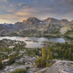
Sawtooth Lake Idaho
 Sawtooth Lake #65880 Purchase
The first destination on my summer photography tour of the Rocky Mountains was the Sawtooth Range of central Idaho. I had been to the Sawtooths for photography several times in the past. However, this was to be my first foray into the famed backcountry. With ample time available I planned to make several backpacks into several of the most scenic locations. The first destination I chose was Sawtooth Lake.
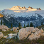
 Trailside view of Sawtooth Mountains #65987 Purchase
Hiking to Sawtooth Lake Idaho
Sawtooth Lake is the largest backcountry lake, and one of the most popular in the Sawtooth Wilderness. It is also probably one of the shortest backpacking destinations. The distance from the Iron Creek trailhead to the lake is about 4.5 miles, with 1750′ of elevation gain. Depending on your physical condition and pack weight the trip could be anywhere from easy to moderately difficult. The first half of the hike is fairly easy and passes through the cool shade of the forest. However, at around 3.5 miles things get serious with a switchback climb to Alpine Lake. Sitting in a cliff-ringed bowl at tree line Alpine Lake is a nice destination in itself. Some hikers decide to base camp here and then day hike up to Sawtooth Lake. I decided to take a pass since I was eager to see Sawtooth Lake.
 Alpine Lake Sawtooth Mountains #65988 Purchase
At the junction of Alpine Lake, the trail gets down to business. For the last mile or so the trail switchbacks steeply up a ridge to Sawtooth Lake. Although it is a bit of a grind it is also the most scenic part of the trail. Here the trees thin out and offer great views of the rugged peaks and ridges. The views make this last stretch go quickly despite the steep climb. If you started later in the day this section can also be hot with the sun beating down on you.
At Sawtooth Lake
When the trail levels out it meanders through a pleasant subalpine landscape of cool streams and small ponds. From here it’s less than half a mile to the lake. If you’ve arrived later in the day you should probably take advantage of any open campsites available in this area. This a good reason to get as early a start as possible. Nearly all backcountry camps in the Sawtooths fill up very quickly. If you arrive late you may not find a spot and be tempted to camp in an undesignated area. Please don’t do this as the vegetation is extremely fragile.
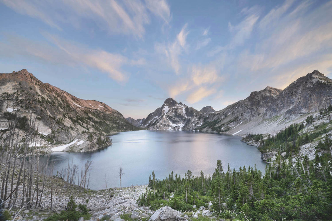
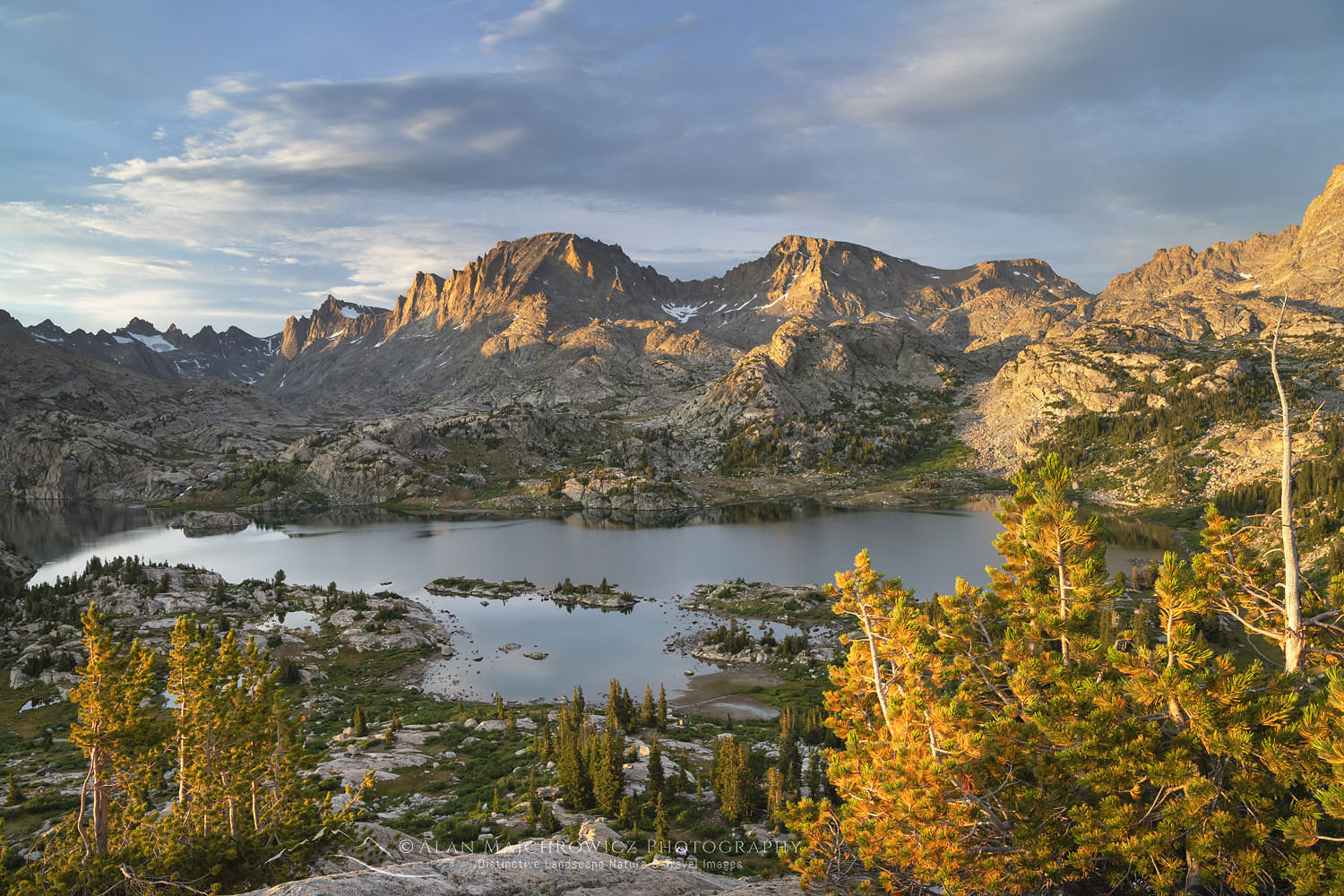
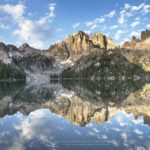
 Sawtooth Lake and Mount Regan #65930 Purchase
After a short hike through this area, I arrived at the fabled view of Sawtooth Lake and Mount Regan. It was a thrill to see this sight in person after viewing pictures of it for many years. While I wanted to just sit and take it all in I immediately went down to the business of finding a campsite. Although I arrived early the best sites with a lake view were already taken. A few minutes of checking out the area yielded a great site among boulders and trees a short distance from the lake.
Photographing Sawtooth Lake Idaho
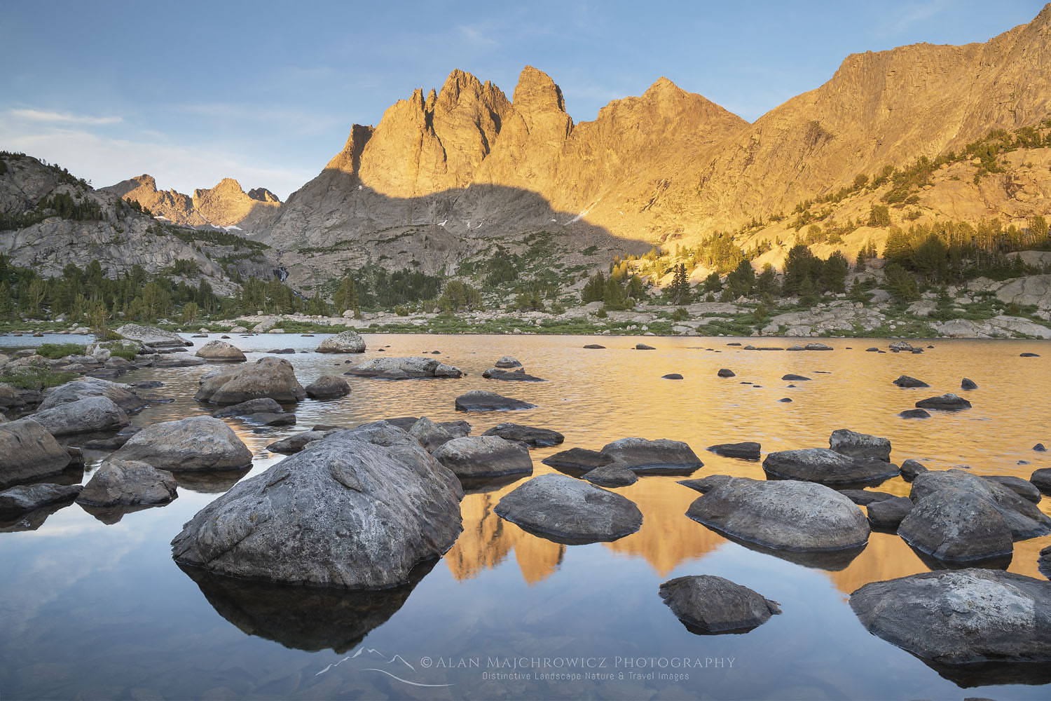
Upon setting up camp, relaxing, and having a bite to eat, it was time to begin scouting the lake vicinity for photo ops later in the day. Two spots that seemed to offer good photo compositions. One was a little south along the shore by a big boulder field, the other higher up at the head of the lake on the trail to McGown Lakes. This second spot was where I decided to set up for evening light.
 Sawtooth Lake Afterglow #65888 Purchase
The trail to McGown Lakes begins at the lake outlet and climbs through rocky bowls dotted with wildflowers. Soon it begins a wide open traverse through scree fields below an unnamed peak. In an area with beautiful views in all directions, this was one of the best. The entire lake was spread out below with Mount Regan as an impressive backdrop. I set up my tripod here and relaxed for a few hours as the evening light came on. I was very fortunate to have some nice wispy clouds at sunset to accentuate the composition. A wonderful end to my first day in the Sawtooths.
 Sawtooth Lake #65898 Purchase
The next morning I set up in the boulder field along the lake shore. I arrived before dawn and was disappointed to see an empty cloudless sky. But here I was, so I waited patiently hoping for some nice light. Fortunately, some nice clouds appeared and it turned out to be a beautiful morning. Returning to camp I noticed that all the others in the area were still sound asleep. It’s always nice to have a beautiful sunrise to yourself, but I feel sorry for those who sleep in and miss it.
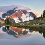
 Mount Regan Sawtooth Lake #65922 Purchase
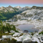
At the south end of Sawtooth Lake
After breakfast, I decided to move on to the other end of the lake. A short scenic mile brought me to the south end of Sawtooth Lake. Most hikers don’t seem to bother with checking out this end so I had it all to myself. I found a nice established camp among some giant boulders and began exploring the area. I was especially interested in hiking a little further south along the trail to see if there were good views across the valley to Baron Peak. The hike below Mount Regan through open rocky terrain was exciting, but the trail soon began to drop into the valley. There were nice views of Baron Peak but not what I had hoped for.
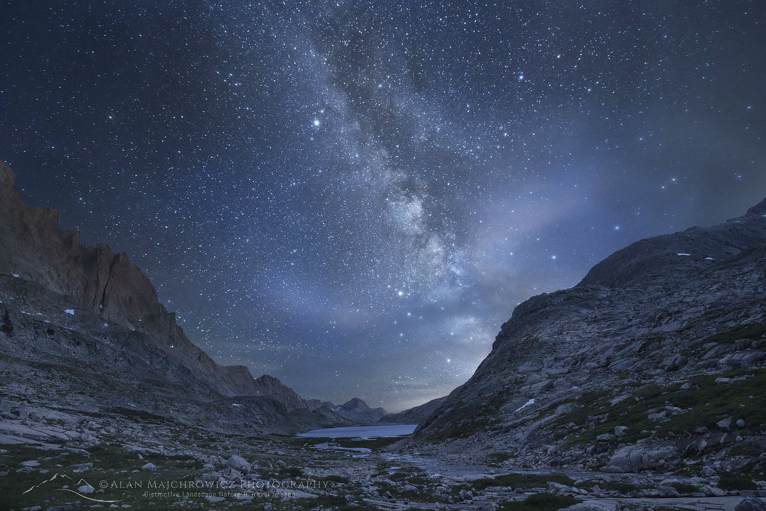
 Night sky over Sawtooth Lake #65938 Purchase
That evening the sky was disappointingly cloudless. To make up for it I decided to take my first shot at night sky photography. The next morning I again set up before dawn in a cloudless sky. Very frustrating but again I waited and hoped. Incredibly just at dawn, a few clouds appeared. What looked at first like a boring morning turned into a nearly two-hour frenzy of photography. Cloud patterns and light continued to change and I came away with plenty of new and exciting images.
 Morning clouds over Sawtooth Lake #65942 Purchase
Later that morning I packed up and began the hike out. It’s always a little sad for me to leave such a beautiful place, but I was thrilled at having my first trip to the Sawtooths a total success. I savored every step I made on the trail and envisioned my return sometime in the future.
Next up: Baron Lakes Sawtooth Mountains
 Morning clouds over Sawtooth Lake #65954 Purchase
If You Go to Sawtooth Lake Idaho
Round Trip Distance: 10 Miles
Elevation: About 1758′ gain, Highpoint 8471′
Difficulty: Moderate
Red Tape: Free Permits are required, available at the trailhead
To get to the Iron Creek Trailhead from Stanley, go northwest 2.5 miles on ID 21, then 4 miles south on Forest Road #619. There are plenty of campsites near the trailhead and along the road to facilitate an early start.
The small scenic town of Stanley Idaho makes a great base for trips into the Sawtooths. Lodging, groceries, restaurants, outdoor gear stores, and a great bakery are in town. There are also many campgrounds in the vicinity.
As mentioned earlier in this post, the Sawtooths are an extremely popular destination. Not only for hikers and backpackers, but also tourists, front country family camping, river rafters, and fishing. During the height of summer just about every campsite, both front country, and backcountry will be filled before noon. So make your plans accordingly to avoid frustration.
One of the best perks of the area is the numerous natural and wild hot springs. Soaking in one along the Salmon River is one of the greatest post-hike activities.
Leave No Trace
Don’t even think about visiting this or any other wilderness area unless you are prepared to strictly follow the guidelines of Leave No Trace (LNT). All wilderness areas throughout the world are under incredible pressure from growing amounts of visitors. Please do your part to help preserve these precious areas for future generations!
To learn more about the principles and practicing LNT please take a few minutes to visit the Leave No Trace Center for Outdoor Ethics. Your children and grandchildren will thank you!
Seven Leave No Trace Principles
- Plan ahead and prepare.
- Travel and camp on durable surfaces.
- Dispose of waste properly.
- Leave what you find.
- Minimize campfire impacts (be careful with fire).
- Respect wildlife.
- Be considerate of other visitors.
Learn about how to protect the places we love to photograph
Visit the Nature First Website

More Posts on the Sawtooth Mountains:
Photographing Cramer Lakes
Alice-Toxaway Loop Backpacking Photography
Baron Lakes Sawtooth Mountains Idaho
 Sawtooth Mountains from Stanley Basin #65845 Purchase
Check out more of the photos from this trip in my Idaho Archives.
All the photos in this post are available as Fine Art Prints and for Commercial Licensing.
Photo Gear Used On This Trip
Nikon D850
Nikkor Lens:
14-24mm 2.8G ED
24-70mm 2.8E ED
70-200mm 2.8E FL ED
Gitzo 1532 Tripod
Really Right Stuff B-55 Ball Head
Assorted Lee Graduated Neutral Density Filters
B+H Polarizing Filter
Vello FWM-N2 Remote Shutter Release
 Morning clouds over Sawtooth Lake #65974 Purchase
Next up: Baron Lakes Sawtooth Mountains
Sawtooth Lake Idaho


 Mount Challenger, North Cascades National Park #61740