Howser Towers Vowell Glacier, Bugaboos

New Images Selkirk Mountains Bugaboos Kootenai Falls

New Images Selkirk Mountains Bugaboos Kootenai Falls

Howser Towers Vowell Glacier, BugaboosBugaboo Provincial Park British Columbia  #62907   Purchase

I’m happy to announce that my extensive summer photography tour has successfully wrapped up. After seven weeks and over 8700 miles driven, with numerous trails hiked, I’ve returned with plenty of new photographs. Most of these new photos are from locations I’ve never photographed in, such as Michigan, West Virginia, Southern Illinois, Ohio, and Pennsylvania’s Laurel Highlands. Scroll down this post to see the complete list of locations and subject matter from this trip.

Mount Sir Donald Selkirk MountainsMount Sir Donald, Glacier National Park British Columbia  #62836  Purchase

The editing and processing of all these photos will take some time, however I have a small selection of highlights ready from the first part of the trip. This first section includes the Selkirk Mountains in British Columbia’s Glacier National Park, Bugaboo Provincial Park, and Kootenai Falls Montana. You can view and purchase prints or licensing of these photos by visiting the top of the New Images Gallery.

This summer again had wildfire smoke filling skies throughout the western states and Canada. However, at the start of my trip I was fortunate enough to experience a brief window relatively free of smoke. Although the smoke returned at Kootenai Falls it provided a warm tone which enhanced to mood of the photos.

Kootenai Falls MontanaKootenai Falls Montana  #63070  Purchase

List of Locations:

British Columbia Canada: Glacier National Park; Bugaboo Provincial Park; Backpacking, Heli-Hiking
Montana: Kootenai Falls; Clark Fork River
Illinois: Starved Rock State Park; Matthiessen State Park; Heron Pond Cache River State Natural Area; Shawnee National Forest, Garden of the Gods
Ohio: Hocking Hills area and State Park
West Virgina: Blackwater Falls State Park, waterfalls and Lindy Point Overlook
Pennsylvania: Laurel Highlands; Ohiopyle State Park; Youghiogheny River; Covered Bridges; Fort Necessity National Battlefield, 18th century re-enactments
Michigan Lower Peninsula: Big Sable Point Lighthouse;  Colonial Michilimackinac,  18th century re-enactments
Michigan Upper Peninsula: Mackinac Bridge; Whitefish Point Lighthouse; Tahquemanen Falls; Pictured Rocks National Lakeshore; Au Sable Light Station; Porcupine Mountains Wilderness, Lake of the Clouds
Minnesota: Split Rock Lighthouse State Park, waterfalls and lighthouse; Tettegouche State Park waterfalls; Grand Marais Light Station; Devil’s Kettle Falls; Grand Portage, High Falls Pigeon River; Boreal Forest; Touch the Sky Prairie
South Dakota: Badlands National Park
Wyoming: Devils Tower National Monument

Purcell Mountains meadowPurcell Mountains meadow  #62882  Purchase

New Images Selkirk Mountains Bugaboos Kootenai Falls

Wind Turbines, two lane highway, Oregon

Summer Fall Photography Tour

Wind Turbines, two lane highway, Oregon Summer Fall Photography TourTwo Lane Country Road, Oregon  #59814

I’m very excited to announce my latest photo schedule. Beginning this week I will be leaving on a Summer / Fall Photography Tour which includes a wide variety of cool locations. While the length of the trip and the specific locations are subject to change, it’s safe to say this one will be big.

Possibly extending into the fall season the trip will begin in the Bugaboo Range of the Purcell Mountains of British Columbia. Then I will be moving on to the Midwest and the Appalachian areas of Pennsylvania and West Virginia. Looping back west will take me through Michigan’s Upper Penninsula and the North Shore of Lake Superior. If time allows on the return home I may also fit in photographing the Wind River Range of Wyoming and a few selected sites in Montana.

Listed below are some of the locations and subject matter I hope to work with. However, with a trip this big it is difficult to say how factors such as weather and time constraints will affect the list. Of course I am always open to suggestions for locations and subject matter you have interest in seeing. Feel free to contact me through email, texts or FB Messenger.

General Locations:
Purcell Mountains British Columbia: Bugaboos, Jumbo Pass
Ohio: Hocking Hills Region
West Virginia: Appalachian Mountains, Babcock and Blackwater State Parks
Pennsylvania: Laurel Highlands Region
Michigan: Lake Michigan Lighthouses, Pictured Rocks National Lakeshore
Minnesota: North Shore Lake Superior
Wind River Range Wyoming
Subject Matter:
Mountain views
Farms/Agriculture
Lighthouses
Waterfalls
Historic Sites
Country Roads and Byways

Thanks for viewing this post!

Blue Rocks Nova Scotia

Bluenose Coast Nova Scotia

Blue Rocks Nova ScotiaBlue Rocks Nova Scotia  #58819   Purchase

Bluenose Coast Nova Scotia

In my last post, I left off with our departure from Cape Breton Island Nova Scotia. In this post, I’ll be talking about our visit to the Bluenose Coast of Nova Scotia. This area of Nova Scotia has been high on my photography wish list for many years. Bluenose Coast contains some of the most famous tourist attractions in the Province. Situated southwest of Halifax the area includes Peggy’s Cove, and the lovely coastal villages of Chester, Mahone Bay, Lunenburg, and Blue Rocks. How the term Bluenose originated is up for debate, some say it is a derisive term dating to political divisions of the late eighteenth century. However, others will say it refers to a bluish variety of potato or the nose color of locals in winter.

Rowboat, Blue Rocks Nova ScotiaBlue Rocks, Nova Scotia  #58804  Purchase

Our drive from Cape Breton Island down to the Bluenose Coast was again a long tiring journey. Not only was the weather rainy discouraging, but the route we took was also longer than anticipated. Instead of taking a direct course via the main highway, we decided on a more scenic drive along the coast. While I won’t say this was a mistake we did find the road to be exceedingly long with very few coastal views. Most of the way traveled through heavily forested lands dotted with tiny villages. Occasionally the roads break out on the coast with views of numerous islands. According to our travel brochures, this area northeast of Halifax is a haven for wilderness-loving sea kayakers. I’d love to be able to return and explore this vast area with a boat.

The Fo’c’sle Pub Nova ScotiaThe Fo’c’sle Pub Chester, Nova Scotia #58700 

At Chester

Between the rain and the torturous road, we decided to finish the drive to Bluenose Coast the next day. We weren’t too thrilled at the prospect of finding our way through the Halifax area at night. After anxiously getting through Halifax in the morning we decided to base our stay at Graves Island Provincial Park. Well situated near all the sites I was hoping to photograph, Graves Island also had some of the best campsites on our trip. After setting up camp we went on to check out the nearby town of Chester. Founded in 1759, Chester is a quaint village on Mahone Bay noted for stately old homes and a thriving artist community. Along with a boat-filled harbor, Chester is also home to The Fo’c’sle, Nova Scotia’s oldest pub. I couldn’t resist photographing the whimsical dragon hanging above the entrance.

After a few weeks of photographing mostly nature-oriented locations, we were finally in Coleen’s environment. Picturesque coastal towns with lots of shops to browse through were something she had been looking forward to. Although I’m mostly a wilderness nature lover I also was enjoying the change. The next day was perhaps the most memorable of the entire trip. It was a big day with lots of sites to see and photograph on the Bluenose Coast. We began it with breakfast at The Kiwi Cafe in Chester, a colorful establishment with great food, after which we proceeded to Lunenburg and Blue Rocks. Along the way, we passed by Oak Island, the site of questionable buried treasure, made famous on the History Channel’s Curse of Oak Island tv show. Needless to say, we didn’t stop by to check it out.

Mahone Bay Nova ScotiaMahone Bay Sailboats  #58726  Purchase

Mahone Bay & Lunenburg

Along the way, we had to stop in the town of Mahone Bay for the annual Scarecrow Festival and antique fair. Even without the festival, the town is worth a stop. Dating back to 1754, Mahone Bay has numerous eclectic boutiques, art studios, antique shops, B&Bs, and restaurants. Of course with the festival in full swing Mahone Bay was overflowing with tourists, including us. We ended up spending several hours there checking out shops and the over 250 whimsical handmade scarecrows. But we had to move on, I was anxious to scout Lunenburg and the tiny fishing community of Blue Rocks. Aside from Peggy’s Cove these two locations are perhaps the most scenic and photographed in all of Nova Scotia.

Mahone Bay Nova ScotiaMahone Bay Scarecrows  #58715  

Lunenburg is yet another old historic fishing town. In my mind, it was the most interesting one we visited. The town sits on a gentle hill overlooking the bay, with many of the historic buildings sporting vibrant colors. For photographers looking to capture these colorful buildings on the waterfront, there is no better spot than a park directly across the bay. You have the option of photographing from the waterfront or up a hill on the edge of a golf course. The latter offers a wonderful elevated view of the town and boats.

Lunenburg Nova ScotiaColorful Lunenburg Architecture  #58737  Purchase

Blue Rocks Fishing Community

After finding these locations and making a few photos we went on to scout Blue Rocks. Being new to the area it was a bit difficult to find among the maze of roads. However, there was no mistaking it on arrival. Blue Rocks is just a small community with several fishing shacks and boats on a calm inlet. The location though is classic, old colorful fishing shacks, and boats moored alongside with islands and the Atlantic as a backdrop. And the rocks are blue, with the layers eroded into fantastic shapes. With crystal-clear water and bright yellow skirts of seaweed, the rocks boats, and buildings present a dazzling array of colors and shapes. I was bubbling over excitement at photographing this wonderful location! The only thing missing though were clouds, the sky was an empty electric blue. Perfect for picnics and leisurely drives but not for photography.

Boat dock Blue Rocks Nova ScotiaBlue Rocks, Nova Scotia  #58778  Purchase

It was still early so we went back to Lunenburg to check out the town and have a bite to eat. We found another gem at the tiny Salt Shaker Deli. I would highly recommend stopping by if you are in the area. The food was wonderful, probably the best seafood chowder in the Province, and the friendly staff and outstanding harbor view made for a memorable experience.  And if this wasn’t enough, as we were finishing our meal I noticed some interesting clouds moving in!

Rainbow, Nova ScotiaBlue Rocks Rainbow  #58795  Purchase

Blue Rocks Evening Photography

We planned to head back to Blue rocks after dinner for evening light, and then hurry back to Lunenburg to photograph the waterfront at twilight. Arriving at Blue Rocks the sky darkened and rain began to come down in sheets. A complete opposite of the earlier sunny blue sky. I was getting discouraged at my prospects when the showers began to move on. The elements for some great evening light were beginning to come together. Firstly a rainbow began to take shape, followed by curtains of rain and clouds being illuminated by the setting sun. Moving around I found many compositions among the boats and fishing shacks. As the light began to peak and fade I worked to photograph one of the most iconic shacks in the last glowing light of the evening. So far this was the best combination of light and subject matter on the trip.

Blue Rocks Nova ScotiaBlue Rocks, Nova Scotia  #58807   Purchase

Blue Rocks Nova ScotiaBlue Rocks, Nova Scotia  #58825   Purchase

Blue Rocks Nova ScotiaBlue Rocks, Nova Scotia  #58811  Purchase

We were also able to get back to the Lunenburg location in time for more photography. I quickly set up and made some photos just as the lights began to turn on in town with a purple twilight glowing above. All in all, it was a perfect autumn day, sightseeing in historic towns with Coleen, great meals, and successful photography. But there was more in store for us along the Bluenose Coast the next day at Peggy’s Cove, our final location in Nova Scotia.

Lunenburg Nova ScotiaLunenburg, Nova Scotia  #58836  Purchase

Cape Breton Highlands National Park

Cape Breton Island Nova Scotia

Cape Breton Island Nova ScotiaCape Breton Island seaside farm  #58624   Purchase

It’s funny how life can be so unpredictable. Some may be tempted to replace “funny” with frustrating, discouraging, exciting, or fun. Last year at this time I was on a dream trip with my wife Coleen to photograph in Nova Scotia and New England. This year I’m stuck at home in the office, working on marketing and fantasizing about future trips. So since I’m not able to get out on the road anytime soon, the next best thing is to relive last year’s trip by writing blog posts.

In my last post, I wrote about our brief visit to the Bay of Fundy in New Brunswick. In this post, I’ll be recapping our visit to Cape Breton Island Nova Scotia, one of the main highlights and destinations of the trip. As with any new location I hoped to see as much of the province as possible. We had to carefully choose only a few of the best locations to visit in our available time. After years of poring over Nova Scotia maps and images, I settled on a couple of areas. For me, Cape Breton Island and Peggy’s Cove Coastal Region were obvious choices. Cape Breton Island represented the rugged wind-swept character of Canada’s Atlantic Provinces.  While Peggy’s Cove Region highlights the historic and thriving culture of the province. There is, of course, much more to see, but these locations will make a good start.

Cape Breton Island Nova Scotia
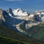
Cape Breton Island, Nova Scotia #58622   Purchase

Onwards to Cape Breton Island

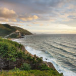
After leaving New Brunswick we drove straight to our first destination, Cape Breton Highlands National Park. On the map, it looked like about a half-day drive. In reality, it took us most of the day to arrive, exhausted from driving, at Chéticamp in the park. Of course, we had to make a few stops along the way. Part of the appeal of Cape Breton Island is its Scottish heritage, most notable along the Ceilidh Trail. Picturesque Ceilidh Trail (pronounced Kay’-Lee) runs along the west coast and has its road signs written in both English and Gaelic. Along the way are quaint villages, world-class seaside golf courses, and North America’s first single malt distillery.

Further north the Ceilidh Trail gave way to the world-famous Cabot Trail. Possibly the most scenic drive in all of Atlantic Canada, the Cabot Trail encircles the entire northern section of Cape Breton Island. During our visit, we focused on the western section of the trail, from Margaree Harbour in the south to Pleasant bay in the north.

Fishing boats, Cape Breton IslandFishing Boats Grand Étang Harbour Cape Breton Island  #58583  Purchase

Cape Breton Highlands National Park

Arriving in Cape Breton Highlands National Park was exhilarating. We were just about as far north in the province as we could drive. The land had begun to take on a wilder primordial feel, even more, evident high on the Cape Breton Plateau. There were few towns, and those were very small fishing outposts. Although Cape Breton Highlands lies only at 46º north, I had the feeling of being on the southern edge of the vast expanse of Canadian subarctic lands. I imagined that if I squinted hard enough I could see Newfoundland, then Labrador, and finally Baffin Island. I should state here that for most of my life I’ve had an obsession with everything arctic. Especially the Canadian Arctic, which holds a tight grip on my imagination, partly due to its rich and often tragic history of exploration.

After setting up camp in Cape Breton Highlands National Park I anxiously began to scout out the coastal drive. Along the west coast, the Cabot Trail climbs high and has stupendous views of the Gulf of Saint Lawrence. At its height, you can see to the Magdalen Islands, situated nearly in the center of the Gulf. I like to think this section of the Cabot Trail is Canada’s east coast version of Big Sur in California. After winding up along the coast the road heads inland to the plateau highlands and a dramatic change of scenery.

Cape Breton Highlands National ParkCape Breton Highlands National Park, Nova Scotia #58564   Purchase

Cape Breton Highlands Plateau

Dominated by boreal forest with a distinct sub-arctic feel, the Cape Breton Plateauis a windswept wilderness of barrens, bogs, and lakes. Most people think of the Appalachian Mountains ending at Mount Katahdin in Maine. However, geologically they continue much further north. Cape Breton Plateau is an Appalachian mountain worn down by glacial activity. To reach the true end of this ancient chain of mountains you would need to travel as far as the highlands of Gros Morne National Park in Newfoundland. Since the weather was grey and forbidding on the plateau I headed back to photograph the coastal drive in the evening light.

While in the park I wanted to hike the Skyline Trail to photograph the iconic view from the top. At the end of the trail, a dramatic headlands cliff overlooks the winding road and the vast expanse of the Gulf of Saint Lawrence. This trail and view are one of the hallmarks of the park. However, my timing to get there was poor. I failed to consider the length of the hike, it would’ve been dark by the time I made it there. I was fortunate to drive to an alternate overlook just in time to make a few photos of evening light breaking through the clouds.

Cape Breton Highlands National ParkCabot Trail Cape Breton Highlands National Park, Nova Scotia #58637   Purchase

Margaree Harbour & Lobsters

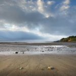
The next day Coleen and I drove south to scenic Margaree Harbour to photograph fishing boats and coastal views. I enjoyed this area, there were picturesque seaside farms, sandy beaches, churches, and colorful boats. An interesting find was Centre de la Mi-Carême, an interpretive center focusing on the Acadian celebration of Mid-Lent with masks, music, and dance. Attracting us to the center was the display of colorful effigies on display in the parking lot. Unfortunately, our visit was cut short as the center wasn’t open at the time.

Back on the lobster hunt, as we found out in New Brunswick, lobster was out of season. However, we were lucky enough to find that in Margaree Harbour the Island Sunset Lobster Pound still had some available. After chatting with the friendly owner and a patron about our travels we hurried back to camp to cook our long-anticipated crustaceans. In the warm afternoon sun, we made a glorious mess of cracked shells lobster meat, and melted butter! This was the way to do it, out in the open air by the sea, not in a stuffy restaurant.

Cape Breton Island Nova ScotiaMargaree Harbour Cape Breton Island  #58615  Purchase

Church Cape Breton IslandChurch in Margaree Harbour  #58607  Purchase

Cabot Trail Coastal Photography

In the evening, and again the next morning, I went out to make photographs along the coast. I had some nice light for photography while in the area but it didn’t last very long. I came back with only a few new images, including one of a beached whale, headless and rotting on the beach. This is usually the situation when visiting a new location. Without prior firsthand knowledge of a location, it’s difficult to be in the right place at the right time. In my experience, I might get lucky a few times on an initial trip. But it normally takes several return visits to understand its character. There are some spots from which I still have not created a defining image, although I’ve been there many times and know it intimately.

Cape Breton Highlands National ParkCape Breton Highlands National Park  #58560  Purchase

Dead Whale Cape Breton Island Nova ScotiaWhale carcass, Cape Breton Island  #58647   Purchase

Over to the Atlantic Side

After packing up our camp we began our drive north and over to the Atlantic side of Cape Breton Island. At Green Cove, we got our first real view of the Atlantic Ocean. Getting out of the truck to stretch our legs I found this to be a great place for photography. The headland is composed of beautiful pink granite laced with striped intrusions. Given the right lighting conditions, I could spend hours here photographing the fascinating patterns. Unfortunately, a storm front was arriving with the first drops of rain which lasted all day.

I wished we had better weather and more time to stay and explore beautiful Cape Breton Island. One of my biggest regrets was having to pass up a visit to the Fortress of Louisbourg National Historic Site. Located on the far eastern edge of Cape Breton Island, the fort is a wonderfully preserved 18th-century military installation. Among the activities here are interactive tours and reenactments of 18th-century life. Including Louisbourg on our trip would’ve meant excluding other important locations further on. And I didn’t want to miss out on photographing iconic Peggy’s Cover and historic Lunenburg. So it was onward into the rain, and part two of this post!

Green Cove Nova ScotiaGreen Cove, Cape Breton Highlands National Park  #58656  Purchase

Bay of Fundy low tide

Bay of Fundy New Brunswick

Bay of Fundy New Brunswick

Bay of Fundy low tideBay of Fundy at low tide  #58545    Purchase

A year ago I made my first visit to the Bay of Fundy New Brunswick. For many years the Atlantic Provinces of Canada have been on my must-see list. Last year my wife, Coleen, and I finally had the opportunity to visit and photograph in this beautiful region. Our plan was to spend six weeks traveling to Nova Scotia and New England for fall color photography. Since we had to drive through New Brunswick we couldn’t miss the opportunity to check out the fabled Bay of Fundy.

Fundy National Park

Fundy National Park was our first stop in the Atlantic Provinces after leaving New England. Fundy National Park showcases a rugged coastline, over 25 waterfalls, a dense Acadian Forest, and of course the famous tides. We excitedly pulled over at the first overlook of the bay. After such a long drive across the continent, it was a welcome sight to see and smell salt water again. We checked in at the visitor center to secure a campsite then quickly set up our home for the night.

Fishing Boats New BrunswickFishing boats, Alma, New Brunswick  #58493   Purchase

We stayed in Headquarters Camp and found it very convenient, being very close to the bay. Campers in Fundy National Park have a variety of options available in three different campgrounds. You can choose between a traditional tent and RV sites, yurts, rustic cabins, oTENTik, or the new Goutte d’Ô. Goutte d’Ô is a structure with a water droplet shape suitable for couples or families. I must warn, however, along with the park’s daily use fee per person, the cost of renting out an oTENTiks, or Goutte d’Ô could be higher than a nice motel room.

Alma, Bay of Fundy

Our next objective was to pay a visit to the small town of Alma in search of lobster. While in town I made some photos of fishing boats moored to piers at high tide. My plan was to make some comparison photos of low and high tides. We searched the town but couldn’t find any open lobster shacks. It turned out the season had closed so there wasn’t any lobster available. So we settled for the next best thing, clam chowder, and fish & chips. I wish I could report that we had a good introduction to east coast seafood, but it wasn’t to be. The clam chowder was very watery, with hardly any cream clams or flavor. Unfortunately, the fish & chips were no better, a small fillet covered in thick very greasy batter. Although we were sorely disappointed, our dining luck will greatly improve in the coming weeks!

Dickson Falls Trail, Fundy National ParkDickson Falls Trail, Fundy National Park  #58487   Purchase

Dickson Falls

Aside from the obvious attraction of the bay and its tides, Fundy National Park also has over 100 kilometers of trails. I wanted to check one of those trails before getting ready for evening photography. I decided on the popular Dickson Falls Trail, a short walk into a forested ravine to a famous waterfall. Upon entering the forest I was immediately struck by the heavy fragrant scent of spruce trees. Forests in New Brunswick and Nova Scotia are classified as Acadian, a mix of northern hardwoods and boreal spruce usually found in the far north. A well-constructed boardwalk trail takes you through a cool green forest that felt more like home in the Pacific NW. Due to all of New England and the Atlantic Provinces experiencing a severe drought, Dickson Falls turned out to be a disappointing trickle.

Bay of Fundy New BrunswickBay of Fundy headlands  #58518   Purchase

Bay of Fundy New BrunswickFog over Bay of Fundy  #58525   Purchase

After the hike, we returned to a wide overlook of the bay and settled in to see what kind of light evening will bring. A quaint feature of Fundy National Park is the placement of red Adirondack chairs in quiet scenic locations. It was relaxing to take advantage of the chairs as we gazed across the bay hoping to see whales. While we didn’t see any whales in the bay I did manage to make a few semi-abstract photographs of cloud patterns.

Bay of Fundy low tideFishing boats at low tide, Alma New Brunswick  #58535   Purchase

Fundy Low Tide

I got up early the next morning to drive down to the bay for low tide. It was quite a sight to see such a low tide. All the fishing boats were now resting high and dry on a gravel and mud seafloor. After scouting for photos along the expansive low-tide beach I headed back to camp to pack up and move on to Nova Scotia. I was hoping to make a stop along the way at Hopewell Rocks to photograph the famous sea stacks. However, as we pulled into a full parking lot the sight of a large number of tour busses was discouraging. I knew from experience that the best views for photography would be crowded with tourists. So with a tinge of regret, we instead drove on to our next main destination, Cape Breton Highlands, Nova Scotia.

It seemed a shame though to have only a little more than a day for this area. I guess we’ll have to come back again!

Bay of Fundy low tide New BrunswickBay of Fundy low tide  #58540   Purchase

Foster Covered Bridge, Vermont

New Images Part 2 New England

New Images Part 2 New England

Bass Harbor Head Lighthouse, MaineBass Harbor Lighthouse, Maine  #59018  Purchase

The last portfolio of New Images from our recent photo trip to New England and Atlantic Canada is now ready for viewing. And, as always, all of the photos are ready to purchase as fine art prints and commercial licensing.

This portfolio wraps up the edit and processing of all new images from the trip. However, in the coming weeks and months I’ll most likely be revisiting many of the files to identify which can be processed into black and white or alternative styles. I’ve already began this procedure with a group I made early on in the trip in the Bay of Fundy. This group of images, composed of just sea and clouds, represents a more minimalist style of photography that I very much enjoy. Be sure to check back soon to see a new post regarding these photos!

Some of the locations included in this portfolio are:

  • Acadia National Park Maine
  • Mahoosuc region Maine
  • Grafton Notch State Park Maine
  • White Mountains New Hampshire
  • Kancamagus Highway New Hampshire
  • Franconia Notch New Hampshire
  • Stowe Vermont
  • Groton woods Vermont
  • Woodstock Vermont
  • Newfane Vermont
  • Bennington Vermont
  • Ricketts Glen Pennsylvania


Foster Covered Bridge, Cabot VermontFoster Covered Bridge, Vermont  #59335  Purchase

Peacham, VermontPeacham, Vermont  #59321  Purchase

Bennington Battle Monument VermontBennington Battle Monument, Vermont  #59477  Purchase

Bruneau River Canyon Overlook Idaho

Bruneau Canyon Idaho

Bruneau Canyon Idaho

Bruneau River Canyon Overlook IdahoBruneau Canyon Sunset  #56320  Purchase

Another location I visited on my recent photo trip to Idaho was Bruneau Canyon. Located on BLM land in a remote corner of the Snake River Plain in SW Idaho. This canyon is more well known to white water enthusiasts than photographers. I wasn’t even aware of its existence until thumbing through an Idaho tourism brochure I picked up in a rest area. Given the hot sunny and windy conditions and a long drive on a dusty gravel road I wasn’t sure I wanted to include it in my itinerary. However I soldiered on and was glad I did.

Bruneau Canyon is roughly 40 miles long, cut through layers of basalt by the Bruneau River. From the overlook  it is 800′ deep. Getting here in mid-day the canyon was a bit of a disappointment, the light was pale and featureless. Aside from the big gash in the earth there was absolutely nothing else around. Just flat plains as far as the eye could see. The only other cause for excitement was a government sign announcing to travelers they are entering an Air Force bombing range.

As always in photography light  means everything and as the sun dipped to the horizon things began to pick up. After sunset when alpenglow kicked in there was some nice warm even light on the canyon walls. The next morning look very promising with wispy clouds glowing in beautiful colors before the sun came up. Unfortunately the majority of them weren’t over the canyon, but it turned out well anyway.

If you decide to visit the Bureau Canyon make it part of a trip that includes other nearby spots like Shoshone Falls or the Owyhee Uplands. Make sure you’re ready to be on your own, although there are great spots along the rim to camp in solitude there is no water, cell phone reception or any other facilities. You also might want to bring a helmet for the objects falling from airplanes!

Bruneau River Canyon Overlook IdahoBruneau Canyon Idaho  #56299  Purchase

Air Force bombing range warning sign SW IdahoAir Force Bombing Range Warning Sign  #56332

Car camping in SW IdahoCamping on rim of Bruneau Canyon  #56311

Kananaskis Country, Alberta

Canadian Rockies Fall Photography

Canadian Rockies Fall Photography

Kananaskis Country, Alberta Canadian Rockies Fall PhotographyKananaskis Country Alberta  #53471  Purchase

Fall is here and very soon the annual parade of colors will begin. It seems like just yesterday I was photographing wildflowers in the North Cascades during the height of summer! This year I will once again be returning to several special locations in the majestic Canadian Rockies. It will actually be a close repeat of last years trip which was cut short due to an early arrival of wet cold weather, hopefully I’ll be more lucky this time.

The trip will begin at Mount Robson Provincial Park in the North followed by Tonquin Valley in Jasper National Park. By the time in finished with those two locations fall color and especially the subalpine larches will be in full swing. I’ll then head south into Banff National Park, Kootenay National Park, Yoho National Park, and Mount Assiniboine Provincial Park.

While I’m on this trip I will of course be in contact with Coleen in the office who will be taking care of regular business and client requests.