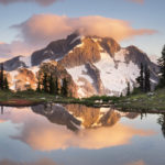
Marriott Basin British Columbia
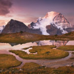
 Marriott Basin alpenglow, #61843 Purchase
Last month I made my third trip to Marriott Basin, in search of new landscape images. Hot on the heels of my recent trip to Whatcom Pass, I wanted to get in as many backpacking photo trips as possible before wildfire smoke returned. This season has been one of the worst in history for wildfires. Both in the western United States and British Columbia numerous large fires are burning.
Located in the southern Coast Mountains of British Columbia, Marriott Basin is an extensive alpine area. Access to the area is from Cayoosh Pass on Highway 99, about an hour’s drive east of Pemberton. Nearby is the extremely popular Joffre Lakes Provincial Park. While the lakes are popular with sightseers and day hikers, the Joffre Group of peaks is wildly popular with climbers and backcountry skiers.
Marriott Basin and Wendy Thompson Hut
Generally above 6000′ Marriott Basin contains several lakes and numerous peaks for climbing, most notably Marriott Peak. My previous trips to Marriott Basin entailed one overnight backpack to Mount Rohr, technically outside the basin. The other was a winter ski trip to the Wendy Thompson Hut, located at the head of the basin. The Wendy Thompson Hut is operated by the Alpine Club of Canada and is open year-round. However, the hut sees most of its visitors during the winter and early spring ski season.
Getting into Marriott Basin is fairly straightforward, with summer access being slightly different from winter. In summer you can drive a couple of miles up a brushy gravel secondary road to the trailhead. Parking and turnaround space is extremely limited and you may need back down the road to find a spot. The total length into the basin from trailhead to the hut is around five miles with about 2000 feet of elevation gain. I say around and about since I don’t carry a GPS and rely on maps and online trail guides instead. Depending on your fitness and pack weight the hike can be from 2-4 hours.
 Trailhead avalanche warning #61910 Purchase
Marriott Basin British Columbia Trail
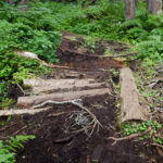
Posted at the trailhead is a large sign warning of and explaining avalanche hazards, which generally is of no consequence in summer. Hikers accustomed to hiking on U.S. trails in the Pacific Northwest may be in for a rude awakening. Well-marked and easy to follow, the trail receives very little maintenance. Climbing over logs around boulders and muddy areas the trail is pretty rough in places. After a short level spell, the trail climbs a headwall very steeply, without switchbacks, through the forest. Near the top of this section is the turnoff for Rohr Lake and Mount Rohr. From here the trail levels off a bit and zigzags around muddy bogs and small meadows until a tricky log crossing of a stream. On my visit the water was low but in late spring or early summer, the crossing must be quite exciting!
 Mount Rohr junction #61905 Purchase
 Creek crossing, Marriott Basin Trail #61892 Purchase
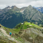
The next section of the trail climbs into the subalpine zone, or the boulder zone as I call it on this trip. As soon as you start breaking out of the trees the trail is almost constantly negotiating rocks and boulders. The constant ups and downs and zigzagging can be very tiring, especially in warm weather. However, the views also begin to open up now, above the ridge tops and over to green Marriott Lake. After reaching the far end of the lake the last bit of climbing to the hut begins. Again, depending on your pack weight this section can feel short or agonizingly long. In all, it’s less than a mile and 200′ higher up. A level boulder-filled meadow with a meandering stream is home to the hut.
 Wendy Thompson Hut #61793 Purchase
Wendy Thompson Hut
The upper lakes were my ultimate destination, so I only paused briefly for a rest and inspection of the hut. Wendy Thompson was a ski patroller and paramedic. She died tragically in 1995 at the age of 33 in a Medivac flight crash in the Queen Charlotte Islands. As a memorial and legacy to Wendy, her parents, and the ACC worked with volunteers to build this hut.
Since my last winter visit, the ACC made some substantial renovations. They extended the entire length and added solar-powered lighting and USB ports. They also replaced the obnoxious smell of kerosene heaters with a wood-burning stove. As is usual in backcountry huts one of the tables was covered in maps, guidebooks, and misc. reading material. Also present was the obligatory cribbage board and multiple decks of cards.
From the hut, the work begins again. Access to the upper lakes is via more and bigger boulder fields without the benefit of a trail. Some well-placed rock cairns mark the way but mostly it’s a pick-your-own-best route deal. Once at the upper lakes, it is wide open wandering in all directions. I set up camp in a spot suitable for easy access to photo ops of the distant peaks and valleys below.
 Boulder field, cairn visible in lower right corner #61849 Purchase
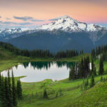
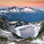
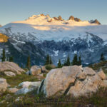
Upper Marriott Basin
The next day I did some exploring and I set my eyes on an easy ridge within my comfort level. Hiking and easy scrambling over boulder slopes brought me to the crest with a new view to the west and north. One of the reasons I picked this particular ridge was for the unobstructed views of Cayoosh Mountain. Sitting at 8200″Cayoosh is a fairly bulky chunk of rock with the north and east aspects covered in glaciers. Looking down between me and Cayoosh was a high pass with a small green lake. To the north was a long deep valley with countless peaks on the horizon. Taking in such a view I immediately wished I had my camp set up here! Photographing in good light would be spectacular. I guess I will need to make another trip back sometime.
Later, back at my camp, I settled in to wait for the evening light. Although the sky was mostly free of clouds, there was some nice alpenglow present, which enabled me to take a few photos. It was nice to watch the progression of layered colors after sunset. First came yellows and oranges, followed by purples and blues of the Belt of Venus.
 Camping in Marriott Basin #61795 Purchase
 Cayoosh Mountain #61805 Purchase
 Upper Marriott Basin #61815 Purchase
Back at the Hut
The next day I had planned to hike out to my truck but on exploring the area near the hut I decided to stay an extra night. Near the hut were small grassy meadows and a small stream among more boulders. I found a nice campsite near the small stream which held potential for some nice photographic compositions. I tried to take some evening photos but the light was bland, especially with no clouds. In the morning it was apparent that the winds had shifted. Smoke once again began to creep across the sky. Although there still weren’t any clouds the light was a bit nicer, with the smoky haze giving a more pastel hue to the scene. I set up my tripod in a few predetermined places and came away with several more photos.
I had a quick breakfast and packed up my gear. Although I wasn’t as successful with photos as hoped I did have a great time. And I did manage to find a new view that was worthy of a return trip.
 Marriott Basin Camping #61863 Purchase
 Marriott Basin #61871 Purchase
 Smokey haze over Marriott Lake #61884 Purchase
Leave No Trace
Please, Please, Please! Don’t plan a trip to this or any other national park, monument, or wilderness area unless you are prepared to follow Leave No Trace guidelines (LNT). National parks and wilderness areas worldwide are under incredible pressure from the growing number of visitors. So, please do your part to help preserve these precious areas for future generations!
Please visit the Leave No Trace Center for Outdoor Ethics to learn more about LNT’s principles. Your children and grandchildren will thank you!
LEAVE NO TRACE SEVEN PRINCIPLES
1. Plan and Prepare
2. Travel and Camp on Durable Surfaces
3. Dispose of Waste Properly
4. Leave What You Find
5. Minimize Campfire Impacts
6. Respect Wildlife
7. Be Considerate of Other Visitors
© Leave No Trace: www.LNT.org
Learn about how to protect the places we love to photograph
Visit the Nature First Website

All photos appearing in this post are available for Commercial Licensing and Fine Art Prints. Click on any image to purchase, or contact me for more info!
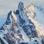
 Mount Challenger, North Cascades National Park #61740